Now, while my video from Friday’s chase is uploading to YouTube, is a good time for me to write my account of how things transpired down in southern Indiana.
The phrase “historic event” rarely describes something good when applied to severe weather. March 2 may qualify as a historic event. The current NOAA tally of tornado reports stands at 117; the final number, while likely smaller once storm surveys have been completed and multiple reports of identical storms have been consolidated, may still set Friday’s outbreak apart as the most prolific ever for the month of March. Whether or not that proves true, Friday was unquestionably a horrible tornado day that affected a lot of communities from southern Indiana and Ohio southward.
The Storm Prediction Center did an excellent job of keeping track of the developing system, highlighting a broad swath of the eastern CONUS for a light risk in the Day Three Convective Outlooks and upgrading the area on Day Two to a moderate risk. On Day One, the first high risk of 2012 was issued for a four-state region that took in southern Indiana and southwest Ohio, most of Kentucky, and north-central Tennessee–a bullseye in the middle of a larger moderate risk that cut slightly farther north and east and swept across much of Mississippi and Alabama as well as northwestern Georgia.
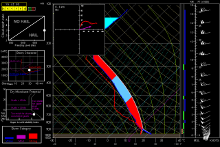
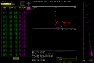
The SPC and NWS offices weren’t the only ones keeping vigilance. Storm chasers across the country were watching the unfolding scenario, among them being my good friend Bill Oosterbaan and me. Here are the February 29 00Z NAM model sounding and hodograph for March 2, forecast hour 21Z, at Louisville, Kentucky. (Click on the images to enlarge them.) With MLCAPE over 1,800 J/kg, 0-6 km bulk shear of 70 knots, and 1 km storm-relative helicity at 245 m2/s2, the right stuff seemed to be coming together. By the time the storms actually started firing, those figures were probably conservative, particularly the low-level helicity, which I recall being more in the order of 400 m2/s2 and up. Simply put, the region was going to offer a volatile combination of moderate instability overlaid by a >50-knot low-level jet, with a 100-plus-knot mid-level jet core ripping in.
I had my eyes set on southeastern Indiana. The problem with that area is, it’s lousy chase terrain along the Ohio River, and it doesn’t improve southward. If there was an ace-in-the-hole, it was Bill’s knowledge of the territory, gleaned from his many business trips to Louisville.
We hit the road at 7:15 that morning, stopping for half an hour in Elkhart so Bill could meet with a client and then continuing southward toward Louisville. Bill was of a mind to head into Kentucky, where the EHIs and CAPE were higher; I was inclined to stay farther north, closer to the jet max, the warm front, and, presumably, stronger helicity. But either choice seemed likely to furnish storms, and since Bill was driving, has good instincts, and knows and likes western Kentucky, I was okay with targeting the heart of the high risk rather than its northern edge.
But that plan changed as we drew near to Louisville. By then, storms were already firing, and one cell to our southwest began to take on a classic supercellular appearance. Bill was still for heading into Kentucky at that point, but after awhile, a second cell matured out ahead of the first one. We now had two beautiful, classic supercells to our southwest, both displaying strong rotation. It was a case of the old adage, “A bird in the hand is worth two in the bush”–except in this case, there were two birds, back to back. And I-64 would give us a clear shot at both of them.
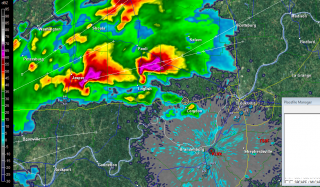
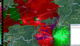
So west we went, and into chase mode. At the Corydon exit, we caught SR 135 north, headed for an intercept with the first supercell. The two radar captures show the base reflectivity and SRV shortly after we began heading up the state road.
A few miles south of Palmyra, we got our first glimpse of a wall cloud maybe four miles distant. That’s all there was at that point, and the hilly, forested terrain afforded less-than-optimal viewing. Within a minute or two, we emerged into an open area just in time to see a funnel descend from the cloud. Tornado!
The sirens were sounding in Palmyra, providing an eldritch auditory backdrop to the ropy funnel writhing in the distance as we drove through town. The tornado went through various permutations before expanding into a condensation cone revolving like a great auger above the treeline. It was travelling fast–a good 60 miles an hour, at a guess. As we sped toward it, the condensation hosed its way fully to the ground and the tornado began to broaden. It crossed the road about a half-mile ahead of us, continuing to intensify into what appeared to be a violent-class tornado with auxiliary vortices wrapping around it helically.
Shortly after, Bill and I came upon the damage path. We pulled into a side road lined with snapped trees, amid which a house stood, somehow untouched except for a number of peeled shingles. The tornado loomed over the forest beyond, an immense, smoky white column wrapping around itself, rampaging northeastward toward its fateful encounters with Henryville and Marysville.
The time was just a few minutes before 3:00 eastern time. While I prepared and sent a report to Spotter Network, Bill turned around and headed back south. We had another storm to think about, and it was closing in rapidly. It wouldn’t do to get caught in its way.
Back in Palmyra, we headed west and soon came in sight of another wall cloud. This storm also reportedly went tornadic, but it never produced during the short time that we tracked with it. We lost it north of Palmyra; given the topography, the roads, and the storm speed, there was no question of chasing it.
From that point, we headed south across the river into Kentucky to try our hand at other storms, but we saw no more tornadoes, nor, for that matter, much in the way of any serious weather. Not that there weren’t plenty more tornado-warned storms; we just couldn’t intercept them, and after giving it our best shot, we turned around and headed for home.
Lest I forget: my worst moment of the chase came when I couldn’t locate my video of the tornado in my camera’s playback files. It seemed unfathomable that I could have horribly botched my chance to finally capture decent tornado footage with my first-ever hi-def camera. After being miserably sidelined during last year’s record-breaking tornado season, the thought that I had somehow failed to record this day’s incredible intercept just sickened me. Fortunately, there were no sharp objects readily available; and better yet, the following morning I discovered that I had simply failed to scroll up properly in the playback mode. All my video was there, and it was spectacular. Here it is:
My excitement over the video was offset by reports of just how much devastation this tornado caused eighteen miles northeast of where it crossed the road in front of Bill and me. Henryville, obliterated. Marysville, gone. Eleven lives lost in the course of that monster’s fifty-two-mile jaunt. And similar scenarios duplicated in other communities across the South and East. The death toll for the March 2 outbreak presently stands at around forty.
In the face of a mild winter and an early spring, Friday was the inauguration for what may be yet another very active severe weather season east of the Mississippi. We can only hope that there will be no repeats of last year’s wholesale horrors. May God be with those have lost loved ones and property in Friday’s tornadoes.


Beautifully written account Bob! A technically difficult chase, well executed. And a word I didn’t know to look up – eldritch. Hope to be over in the US for a few weeks come late May early June.
Michael, good to hear from you, and thanks! Bill did a fantastic job of navigating, and I was pleased with how my own forecasting panned out. You may have picked a good year to chase in the States, and certainly the right time frame. I have a personal thing about May 22, part statistic and part superstition. Blessings to you and safe chasing this season!
May 22 was certainly noteworthy last year. Chased 5/16 to 5/30 last year in the US & was grateful to be in mid Oklahoma and not Joplin on the day.
You guys did an amazing job! Way to get in there up close and get awesome shots. What a day that turned out to be.
Incredible video!!! The school you passed at the 1:55 mark of the video is where my three boys attend. In fact the white van turning onto the school road as you passed by was my wife rushing to get the boys before the storms arrived. I was on the phone with her when she made the turn, and your video gives me an idea of what she experienced during those very frightful moments.
By pausing your video at that intersection, I could establish a line of sight to the tornado and determine fairly accurately where it was along its path at that very moment. I estimate it was just over 6.1 miles away from the school, but given its size looked so much closer.
I would like to have a copy of this video if at all possible. Thanks for what you do.
Thanks, Adam! Bill did a fabulous job navigating and got us to within a half-mile. He knew that road, which I didn’t realize, and I was starting to get nervous. I’m a maiden aunt next to him. But my forecast turned out pretty well. That was indeed one heck of a day. I figured you’d be out chasing–glad you got in on it.
Jason, thanks for sharing your wife’s account. That had to have been a scary moment for her! Luckily the school was well out of the path of the tornado, but other communities obviously weren’t so fortunate. I’ll put in a plug here for owning a NOAA weather radio. Every household should have one; weather radios should be as standard as fire/smoke alarms. The best warning efforts by the NWS and the media are only effective if people get them, and weather radios are one valuable means of disseminating warnings. This is particularly true at night. At 3:00 a.m., a radio alarm sounding could be a life-saver for families sound asleep as threatening weather bears down on them.
Re getting a copy of the video, I’m not sure what I’ll be doing later in the year. If I manage to capture enough good footage, I may make a collection, but it’s too early to tell right now. I’m not presently at a point where I’m ready to burn any CDs, but the video is easily viewed anytime here on this blog or on YouTube. Check in here toward the fall and see whether I make any mention of doing a video.
Good plug about owning a weather radio. My mom bought us one for Christmas a couple years ago. It sits on the dresser in our bedroom completely unnoticed until it’s needed.
Since you plugged the radio, I’ll also put a plug in for incorporating a “tornado bunker” into your design if you’re building a home, because sometimes a basement is not enough.
I asked about the getting the video only because I didn’t know how long you would leave it up on youtube.
I registered to receive your updates, but I’ll check back from time to time.
I was truly amazed at your footage. I traveled Hwy 135 for 3 years from Salem to work at New Salisbury. With this in mind, I recognized all the sites. One thing I would like to add is this, after it passed over the highway, it OBLITERATED the town of of New Pekin, homes at Jordan Lake& also on Daisy Hill area above Borden IN. Most news accounts are always about Henryville& I am just as heartbroken for them, but because their school was destroyed,they get most attention. Being from Washington Co., I just want everyone to remember our victims of this massive storm. A young family of five, lost their lives. Numerous other still in critical condition from injuries.Do NOT forget Pekin IN….Plz?
Jason, not to worry–the YouTube video will stay up indefinitely. Since it’s embedded in my blog post, I have every incentive to leave it be.
Pam, you’ve offered an eloquent reminder of other communities affected by this tornado. I’ve heard the names of these towns but didn’t realize the damage in them was so wholesale. An entire family of five got killed in New Pekin? That’s beyond tragic. I am so sorry for the people who lost loved ones and homes in this and other of the storms.
Great watching the development with that tornado and compelling write-up. Is that the highest bulk shear you’ve encountered? Or as high as any? For basis of comparison, the Ef-5 Parkersburg storm apparently was measured at 55 kts. (found that reference from a senior Met’s student article: The Parkersburg, IA EF-5 Tornado: Destruction Amidst the Rain Sarah A. Monette
The salemleader.com has the obituaries. The young Mom, Dad, son, age 2& infant 7 wks were killed day of the storm. Another child,18 mo., ironically named Angel, was found nearby in a field. She was statflighted to Louisville hospital& it took several hours before her family could be with her& to be even identified, since her parents had been killed when the tornado hit New Pekin. Tragically she died Sunday evening from her severe head& neck injuries….
Bill and I both read about that. It’s so sad. I didn’t realize that there were four other family members who lost their lives–I thought it was two. Either way, there’s something about the death of a child that’s particularly poignant. And an entire family, lost. There’s not much I can say. Things like that go beyond words.
How were the warnings for these storms? With that tremendous forward speed, I wonder how prepared people were. Definitely always worse when a child dies–not having had the chance to live more of life–but horrible for anyone. No bright side there beyond the ongoing improvements in forecasting.
I think it helped tremendously that we had been forewarned with this new PDS alert they put out. People become complacent with the advanced technology forecasters have. I have always been terrified of storms since childhood& am maybe sometimes overly cautious. But I am hoping people will now prepare& take more precautions when our weather foecasters say PDS…. Our Louisville TV stations do a great job of staying on the air& were tracking well this tornado as it developed at the entrance to Washington Co. I was proud of that until it hit between Pekin & Henryville, then our cable went out. Luckily I own a scanner & was kept informed by local law enforcement, who also did outstanding! Hopefully from now on when a PDS is issued, they will heed the warning! Also kuddos to you storm chasers who help advance this technology!