I’ve never witnessed anything like the tornadoes of last Saturday in South Dakota. If supercells were sushi and I could order a al carte, what I got is exactly what I’d have ordered, with the exception of how this chase ended up. But that’s material for a different post. Suffice it to say that in terms of both the storms and the overall experience, May 22, 2010, truly was the storm chase of a lifetime.
Yet I came close to missing it. The forecast models were all over the place with the synoptic setup. The GFS indicated formidable capping. The NAM offered more hope, but convective inhibition was still clearly a huge consideration. And the upper-level winds looked borderline.
But if the right ingredients did come together and the cap broke–and it looked like there was a chance that this could happen–then a whopping 5,000 j/kg CAPE would be at hand to produce explosive convection.
So Mike Kovalchick and I pulled the trigger. The potential was worth the risk of traveling 1,000 miles for a blue sky bust. My friends and long-time chase partners Bill and Tom Oosterbaan had also been tipping on the fence with this setup, but they, like Mike and me, decided it was worth a roll of the dice. So off went the four of us in Mike’s Subaru Outback, headed for South Dakota.
We stopped in Murdo to gas up and bumped into a few other chasers, including Ben Holcomb, Adam Lucio, Danny Neal, and Scott Bennett. We would run into these guys again later, but, as I’ve already mentioned, that’s for another post.
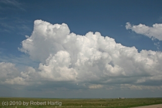
Leaving Murdo, we dropped down to White River to wait for more data. Mike got antsy about capping in our area, though, and he was right. So we hopped back into the Outback and headed north toward a nice field of bubbling cumulus. These were becoming more aggressive to our east, so we caught US 212 and headed toward Gettysburg. Just after we crossed the Missouri River, the cap broke and a tower began to billow upward. Things happened rapidly after that.
With MLCAPE in the neighborhood of 4,500 j/kg fueling its updraft and a 50 kt H5 jet to help organize it, the storm went supercellular almost from the get-go. From left to right, here are Bill, Mike, and Tom watching it get its act together. It didn’t take long for that to happen.
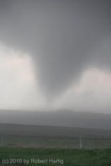
Half an hour later, 45 minutes tops, the first tornado of the day formed a mile southwest of us and strengthened rapidly into a robust cone that, moving at maybe 25 mph in a northeasterly direction, crossed the road to our west and passed to our north at a distance of a quarter of a mile. Quite the exhilarating experience, but also somewhat frustrating as my camera chose that time to give me trouble. Moisture from the rain lashing in on the rear flank downdraft was likely the culprit, but in any case, the shutter refused to snap. I should have brought a plastic bag for my camera. Nevertheless, I managed to get a few decent photos.
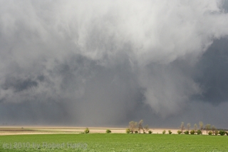
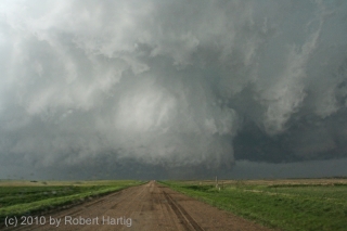
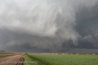
The tornado lifted a few minutes later and a new one rapidly formed. At this point the storm had moved off to our northeast, but it was moving slowly. For once, we weren’t chasing a rocket ship. The storm was easy to keep up with, providing ample opportunity for repositioning, and the view from the rear was flat-out spectacular. The second tornado grew quickly into a large, white cone and then a wedge, positioned underneath an amazing, bell-like mesocyclone. The structure was just unbelievable, with turbulent swirls of cloud wrapping around the parent circulation like daubs of frosting on an immense, revolving birthday cake. Nothing short of a work of art, an awesome sculpture of wind-carved moisture drifting across the prairie. It’s strange and amazing that something so violent can also be so beautiful. The first photo at the top of this post gives you a closer view.
This tornado continued to strengthen and the mesocyclone to lower as we drew closer. We tracked with it along US 12 as it took an eastward turn and headed toward the town of Bowdle.
With horror, we realized that we were about to watch a large, violent tornado strike a community. It looked like it was maybe half a mile to our north* and, taking a right turn, was heading slightly southeast toward the road ahead of us according to the GR3 SKIT marker. We pulled aside to avoid getting eaten. Other than that, all we could do was pray for the people in Bowdle.
There was nothing pretty about this tornado anymore. It was a smudge of darkness boiling beneath a low and intensely agitated cloud base. The wind was powerful, and as we sat there, a bunch of large plastic conduits came tumbling across the field in our direction. Fortunately, these missed us, and the tornado changed its course, just sideswiping the north end of Bowdle and taking out some large, high-tension electrical towers.
Had the tornado not shifted, I am as certain as can be that we’d have witnessed another Greensburg, Kansas/Parkersburg, Iowa scenario. Thankfully, considering what might have been, this violent wedge had relatively minimal impact. The damage it did cause has subsequently earned it an EF-4 rating.
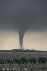
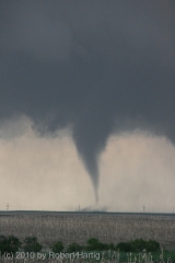
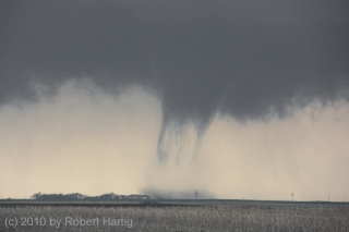
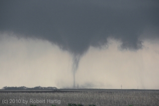
The Bowdle tornado dissipated east of town and the storm once again pulsed, giving us time to get ahead of it and position ourselves to its southeast before it dropped its fourth tornado. This one was the most photogenic yet, going through a variety of forms and phases. At its inception, it reminded me of a picture of a tornado in Gothenburg, Nebraska, that I saw in a weather book as a kid. Really a beauty, a classic, with a long, dark elephant’s trunk kicking up dirt in the open field a mile to our northwest.
The tornado morphed into a truncated tube with multiple vortices circling around its base like braids in a rope, then into a needle. It finally reconsolidated into another classic, Kansas-style funnel, as photogenic as you could ever hope for, before
finally dematerializing, leaving behind it nothing more than a troubled cloud base. How can something so powerful hinge on a balance so delicate that it can translate from a killer into nothingness in a matter of seconds?I’ve presented the photos of this last tornado sequentially to give you a sense of its life cycle. But as visually stunning as it was, the structure of its parent
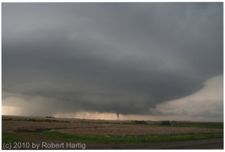
supercell was no less impressive. I like to see the big picture. Tornadoes are just a part of the storm; there’s much more to enjoy as well. Beaver tails and tail clouds. Updraft towers. Wall clouds. The fabulous, banded look of a mesocyclone.I’ll leave you with one last photograph of the entire scene, with the tornado spinning like a dervish in the distance beneath the storm. What followed next is a story in itself, one that I’ll never forget.
Don’t worry, I won’t leave you hanging. Look for Part 3, coming soon to a blog site near you.
——————–
* November 26, 2011: I’ve done some minor editing to this post to correct a couple of factual errors. In doing so, I’ve chosen to let my statement stand about my perception of the distance. Records indicate that the tornado in fact passed a mile north of Bowdle. It certainly looked closer than that to me when it was approaching the town–in fact, I thought it was starting to turn right at one point–but my lack of experience with such a large and powerful tornado, the lowness of the cloud base, the intensity of being in so violent a storm environment, and the excited commentary within the vehicle probably all influenced my perception of the distance involved.
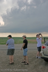
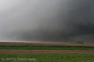


For those viewers in Bowdle(or perhaps in Minnesota or Canada)..if you happen to find that an tan hat shown in the 3rd photo..could you please return it to me? It was ripped off my head by the RFD winds around the Bowdle Wedge..and it was my favorite hat! 🙂
Seriously Bob, very nice job. Looking forward to our next great chase..and the 3rd part of your blog on this storm.
Glad you guys all hit the jackpot. That’s a catch and drama that chasers will probably be still telling a decade or more later. And some great writing here Bob, as you always do, but this in particular catches the eye with the imagery (I wonder if you could get into National Geographic magazine or something like that with a feature story):
—
The structure was just unbelievable, with turbulent swirls of cloud wrapping around the parent circulation like daubs of frosting on an immense, revolving birthday cake. Nothing short of a work of art, an awesome sculpture of wind-carved moisture drifting across the prairie.
NIce work, Bob! Glad I was part of it.