In a recent thread on Stormtrack, storm chaser Shane Adams speculated that all tornadoes exhibit some degree of multi-vorticity. He opened up a topic that has intrigued me for a while.
Just how deep does multiple vorticity extend into a tornado? It may go deeper than most of us chasers imagine. We all understand that many tornadoes display multiple vortices, and a lot of us have witnessed the phenomenon firsthand. It’s possible, though, that the process we call a tornado is a actually an entire complex of vorticity consisting of rotations within rotations. It’s no secret that circulation ranges downward from synoptic scale to mesoscale to microscale; why shouldn’t it continue to do so on increasingly smaller scales? Maybe this concept is nothing new to tornado researchers, but I haven’t heard it discussed to any degree in the general storm chasing community.
While I used to associate multiple vortices with larger tornadoes, it’s the smaller ones that in recent years have intrigued me as I’ve taken a closer look. Some of the more transparent tornadoes have revealed fascinating inner structures, including a sheath-like outer wall cloaking a vigorous center, and a sort of braided appearance that has made me think of the strands that weave together to compose a rope. The 2007 Elie, Manitoba, F5 drillpress is a good example. Check out this video and I think you’ll see at least some of what I’m talking about, particularly around 4:17 into the clip.
Another video of this same tornado, shot at a closer location, offers an excellent front-row view of the tornado as it dissipates. Unfortunately, I can no longer locate that video on YouTube, and I really wish I could, because as I recall, the close-up of the tornado in its last couple of seconds amazed me. The funnel appeared to unravel; for a brief moment, you could see it separate into what I’m going to call vortex strands as its energy abruptly gave out, following which it simply vanished. As striking as how quickly the tornado transformed from a town-wrecker into nothingness was the manner in which it did so.
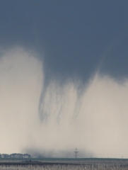
More recently, I finally got a good firsthand look at extensive, small-scale vortices on May 22 this year in South Dakota. The much smaller, highly photogenic tornado that followed the massive and violent Bowdle wedge was a shape-shifter that went through some fascinating transitions. Parking itself in a field a mile northwest of our vantage point, unobscured by rain, it was beautifully visible and offered a study in multiple vorticity throughout its life. For me, the high point was when the funnel assumed the form of a truncated tube, with delicate tendrils of condensation circulating underneath it one after the other like horses on a merry-go-round. (My thinking is that a pocket of drier low-level air stripped out condensation except in the places where the vortex strands rendered the pressure low enough to make themselves visible.)
In the photo (click on the image to enlarge it), some of the vortices are apparent, but if you look closely, you’ll notice that some of the larger vortices actually appear to be made up of more than one vortex strand. You’ll also see a tendril or two appear to branch off. In all, I’m able to make out eleven strands, ranging from the obvious to the nearly undetectable. Granted, I may be pushing things; my point is that the circulations in this tornado were numerous, varied in scale, and complex. I suspect that there were even more vortices present than meets the eye, but I’m not going to force the issue because I’m no scientist, just a thoughtful observer with an aversion to crackpotism.
If there’s any recent weather-related post on this blog that I hope will draw some solid, informed comments, it’s this one. I’d love to get the opinions of others in the storm chasing community; and while I don’t expect that it will happen, I’d be extremely interested in hearing from those who are actually involved in tornado research.


