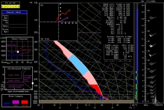
I had reconciled myself with the thought that this autumn’s storm season would be a no-show in the Great Lakes and Corn Belt. Leave it to the atmosphere to prove me wrong, but I’m not complaining. How’s this for a NAM forecast sounding for October 23 in Des Moines, Iowa (click on image to enlarge)?
Maybe not the sexiest hodograph, but I won’t kick it out of bed for eating crackers, and you’ve got to love that 1,811 J/kg SBCAPE. Storm-relative helicity could be better, but still, you got yer 0-2 km EHI of 2.1, yer -6.4 LI, 4 km VGP of .3, nice influx of moisture, good upper level support…what more do you want this time of year? Eggs in your beer?
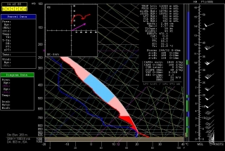
Sixty-five miles southeast of Des Moines in Moravia, the sounding for 21Z looks even better with slightly bigger CAPE, -6.8 LI, a curvier hodograph, a southwesterly H5 cruising along at a stout 50 knots, BRN of 26, and better 0-6 km shear. Bulk shear is actually a bit of a concern–the NAM sounding gives a less optimistic view of it than does the map–but we’ll see how that plays out in future runs. I have a hard time believing that shear won’t be adequate.
I’m seriously contemplating going after this scenario. And it’s just a forerunner; another, stronger system looks to be moving through the Great Lakes in the Monday/Tuesday time frame, with backing surface winds pumping a nice plume of moisture into the region.
All in all, those of us up here in the great north woods may get one or two last whacks at some decent storm chasing and maybe even a few tornadoes before the snows fly. I’m keeping a close eye on this setup and crossing my fingers.


