Remember When . . . ?

Remember when tornado photos were all black-and-white, and you only saw them in the newspapers?

Remember how rare it was  to see them?

Remember newspapers?

Remember watching The Wizard of Oz every time it played on TV, and never missing a showing, just so you could watch the tornado scene? (“It’s a twister! It’s a twister!”)

Remember how fascinated and delighted you were when they showed those grainy old movies of tornadoes in school, or sometimes on TV, and how you wished they’d replay them and then replay them again so you could watch them over and over and over?

Remember when you first saw that incredible photo of twin funnels south of Elkhart, Indiana, taken by photographer Paul Huffman during the 1965 Palm Sunday Outbreak? And that dramatic image of the Xenia, Ohio, tornado shot at just a quarter-mile away from Greene Memorial Hospital during the 1974 Super Outbreak?

Remember your first successful chase? (As if you could ever forget.)

I remember mine. It was in August 1996 across central Michigan, roughly along the M-21 corridor. North of Saint Johns, Michigan, I watched as a beautiful tube dropped from a classic supercell that was as sweetly structured as anything I’ve seen on the Plains. Both the tornado and its parent storm were gorgeous–and I was elated.

Remember when there were no laptops, no Android phones, no mobile data, no GR3–just your car, your weather radio, maybe a tiny portable TV, and a ton of hopefulness and excitement as you drove happily down the highway toward a sky full of rising towers?

Remember when seeing a tornado was rare and busting was something you simply expected and took in stride as part of paying your dues?

Remember before the movie Twister came out?

Remember before the Stormchasers series?

Remember when storm chasing wasn’t “extreme”?

Remember when storm chasing barely was at all?

Remember when Storm Track was a print newsletter published by pioneer chaser David Hoadley? I regret that I never subscribed, because I could have learned much from it.

Remember when the online version was a resource everyone welcomed and loved, not a point of contention among some chasers? I’m so glad the worst of that scuffle is a few years behind us now.

Remember when there was no live stream to fuss with, no competing with a league of other chasers all getting similar footage of the same storm, and no rush to process your video and get it to the networks first? (Not that I would know about that last point personally. I’ve never gotten the hang of it and don’t particularly care.)

Remember when there was nothing to prove, no reputation to make or uphold, and no stripes to earn?

Remember when it was just about the storms, period?

Don’t you wish it still could be?

Why can’t it?

Remember how excited you were when you first got hooked up with a laptop, GR3, and mobile data?

Remember how, before then, you used to stop at airports and small-town libraries just to get a glimpse of the radar?

Remember when there was no TwisterData, no HRRR, no SPC mesoanalysis graphics, no easy way to obtain forecast soundings, no abundance of forecasting resources available at just the click of a mouse button?

Remember when you weren’t even aware that there were forecasting resources available to you?

Remember your first exposure to the SPC forecast discussions, reading through all that arcane gobbledegook and thinking, “These people speak Martian”?

And then thinking, “Maybe if I just head for the center of where it says ‘Moderate Risk’ . . .”?

Remember discovering COD and looking over their forecast maps and not having a clue what they meant or how to use them? You pulled up the 500 mb heights/wind map and admired the pretty colors and thought, “This looks like it could mean something.”

Remember not knowing the difference between GFS and ETA and RUC?

Remember ETA and RUC?

Remember knowing absolutely nothing about forecasting, and how you struggled to learn, and how thrilled you felt when you finally pieced things together and successfully picked a target, or at least had your forecast verify?

Remember all that?

Never forget.

Many of you are too young to have experienced some of the things I’ve mentioned. You missed out on something good. It doesn’t all sound good, I’ll grant you–no in-car radar, no access to a bazillion free online weather resources–but it had its virtues. Not that I’d care to go back to caveman days, but I’d love to reclaim their spirit.

The beat goes on, and those of you who boarded the bus farther down the road are building your own list of remember-whens. But we who are in our mid-forties and older can recall simpler times. They were far less technically advanced, but they were also infinitely less frantic and driven overall. I guess you have to reach at least fifty years of age before you get to say stuff like that. It’s the province and privilege of duffers. I qualify, and I’m okay with that.

I wish I could claim something akin to the number and quality of tornadic encounters, and the knowledge gained thereby, and the photos to show and the stories to tell, possessed by some of the luminaries who are my age or not all that terribly much older. Those guys have got a lot to remember! But what’s mine is mine, and it’s enough to reminisce upon. If you got your start when storm chasing was of a different character than it is today, you know that you were privileged to come up in a special time, a time that can never be reclaimed. And memories of those days are well worth treasuring and reflecting on and feeling grateful for the experiences that created them.


April 3, 2012, Dallas Tornadoes and a 1974 Super Outbreak Retrospective

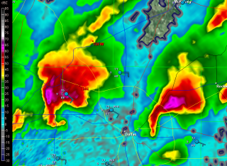
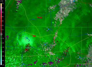
Now that all the excitement is over, here are a couple radar grabs from shortly after 3:00 p.m. EST (1903z) of two tornadic supercells moving across Dallas. Click on the images to enlarge them.

I was on the phone with my brother Brian at the time when I took the screenshots. He, my sister-in-law, Cheryl, and my nephew, Sam, live on the eastern side of Dallas. Worried about their safety, I gave Brian a call. It occurred to me that, once the storms had passed, Brian might enjoy seeing a couple of the radar shots that had prompted my concern.

The storms fired when moist, easterly surface winds collided with an old, eastward-moving outflow boundary. There’s plenty of lift and helicity in that combination, and with good instability and adequate upper-air support, supercells and tornadoes were the result. The event was extremely well-covered, as you’d expect when a major city is in the crosshairs in this age of live streaming and hi-def camcorders. Facebook was abuzz with chatter and images as the scenario unfolded.

But it’s all finished, and now we wait for official surveys to fill us in on the full scope of storm damage. From the videos and photos I’ve seen, some of the tornadoes were quite large, but for all that, it sounds like their impact was relatively minor. Of course, in the neighborhoods where homes got damaged or destroyed, it was calamitous, but considering what could have been, Dallas suffered a flesh wound, not a severed limb. So far I haven’t heard reports of any injuries or fatalities; let’s hope that continues to be the case.

One irony of this event is that it falls on a date that affords ample grounds for comparison. Thirty-eight years ago on April 3–4, the infamous 1974 Super Outbreak claimed 319 lives, a figure only recently surpassed by last year’s devastating April 27-28 Super Outbreak. One hundred forty-eight tornadoes raked a thirteen-state region in the East and South, and out of that number, six tornadoes were rated an F5 and twenty-four, an F4. Even the 2011 Southern Outbreak, violent, deadly, and prolific as it was, didn’t rival that statistic, although it certainly came very close.

Dallas today saw nothing like the disasters that unfolded back then in Xenia, Ohio; or Brandenberg and Louisville, Kentucky; or Monticello, Indiana; or Guin, Alabama. That’s a good thing. Such benchmarks are not the kind you ever want your own town to challenge, particularly if your town is as large and populous as Fort Worth or Dallas.

If you want to get a fascinating and gripping retrospective on one facet of the 1974 Super Outbreak, spend a little time listening to these recordings of the blow-by-blow radio reportage from WHAS as the Louisville tornado moved through the city.

Or for a really eerie experience, turn up the volume and listen to this MP3 of the Xenia, Ohio, tornado as it approached and ultimately destroyed the apartment of a Xenia resident, who wisely abandoned his cassette recorder to seek shelter in the basement.

And that’s enough of that. It’s time for me to pull away from the computer and go practice my saxophone.

April 27, 2011, Southern Outbreak: When a Nightmare Becomes Reality

The death toll from yesterday’s tornadoes in the South presently stands at 231,* and it continues to climb. In the battered town of Tuscaloosa, Alabama, 36 people are dead; in Birmingham, at least 30 more.** From

Mississippi to as far north as upstate New York, the worst tornado outbreak in 37 years has left communities sifting through a battleground of leveled buildings, crumpled automobiles, downed power lines, tortured trees, and a horrifying number of casualties. This has been no mere tornado outbreak; it has been a tornado nightmare.

“You’re talking about whole neighborhoods of housing just completely gone,” said Birmingham Mayor William Bell in an NPR interview. “Churches, gone. Businesses, gone. I’m not talking about just roofs being blown off, but just completely gone.”**

I knew that a dangerous weather event was brewing in the South yesterday. But with my mother undergoing a knee replacement, I spent most of the day at Blodgett Hospital here in Grand Rapids, Michigan. I knew nothing of what was transpiring down in Mississippi, Tennessee, and the epicenter of the outbreak, Alabama, until later in the evening, when I finally left the hospital, fired up my laptop, and got my first look at the radar.

There it was, spread out before me: a blitzkrieg of intense supercells swarming across Alabama and Tennesse, attended by so many tornado reports that they obscured parts of the map. My heart dropped into my gut. I didn’t need any news reports to tell me that something awful was happening and people were getting killed.

Immediately I thought of my long-time friend and storm chasing partner, Bill Oosterbaan. He was down there somewhere in Alabama. I had no question that he’d seen tornadoes, but was he safe? I couldn’t reach him at first on his cell phone, but eventually we connected and Bill shared his story. He had been about a quarter-mile behind a tornado that hit Huntsville and gotten rained on by debris. It sounded bad, but Bill was okay, had witnessed five tornadoes, and had gotten video footage.

After talking with Bill, I began searching for news on Facebook and the Internet. The first video I saw was Chris England’s footage of the Tuscaloosa tornado as it chewed through the city. “Andover!” I thought. “It looks like the Andover tornado.” (An F5 monster that struck Andover, Kansas, on April 26, 1991.) More YouTube videos followed: Mind-boggling views of the Tuscaloosa storm. TWC footage of a violent, mile-wide wedge moving through Birmingham. An intense tornado striking Cullman. It was horrible. The storms were ongoing even as I watched, and it dawned on me that, overworked as the word “epic” has become, here was a situation where it applied.

I am appalled by the news and deeply saddened. As good as today’s weather warning system is, nevertheless the death toll is mind-numbing. I frankly expected a few score fatalities, and that in itself would have been too many. Lives are lives. But this many lives…it is just sickening. Were it not for the unswerving vigilance of the Storm Prediction Center and the National Weather Service; and were it not for today’s NEXRAD system that blankets the nation with Doppler radar to provide coverage that far outstrips what existed during the historic 1974 Super Outbreak and 1965 Palm Sunday Outbreak; were it not for these things, then the death toll from yesterday would have been apocalyptic. As it stands, it is horrifying, and the number continues to grow.

My writing on this event is finished for now. There is simply too much to say and too much news that is yet breaking, along with countless hearts. The story has just begun, and more can be told only as it becomes known. My thoughts and prayers go out, with those of countless other storm chasers, to the survivors of this terrible disaster.

————————————

* From CNN’s live blog.

** From NPR’s news blog, “The Two-Way.”