 Last year’s abnormally balmy March opened for storm chasers with a lion-like roar on the 2nd with a deadly outbreak of tornadoes along the Ohio River southward. But from then on, with the exception of April 13 and 14, the season dwindled into a pathetic, lamb-like bleat.
This March has been the polar opposite, and I do mean polar. Many chasers have been champing at the bit due to a wintry pattern that has simply refused to let go. But that may finally be about to change, and April may be the month when this year’s chase season starts to howl. For the last several days, I’ve been eyeballing a large trough on the GFS that wants to invade the Great Plains around April 8, shuttling in Gulf moisture and also suggesting the possibility of warm-front action farther east on the 9th.
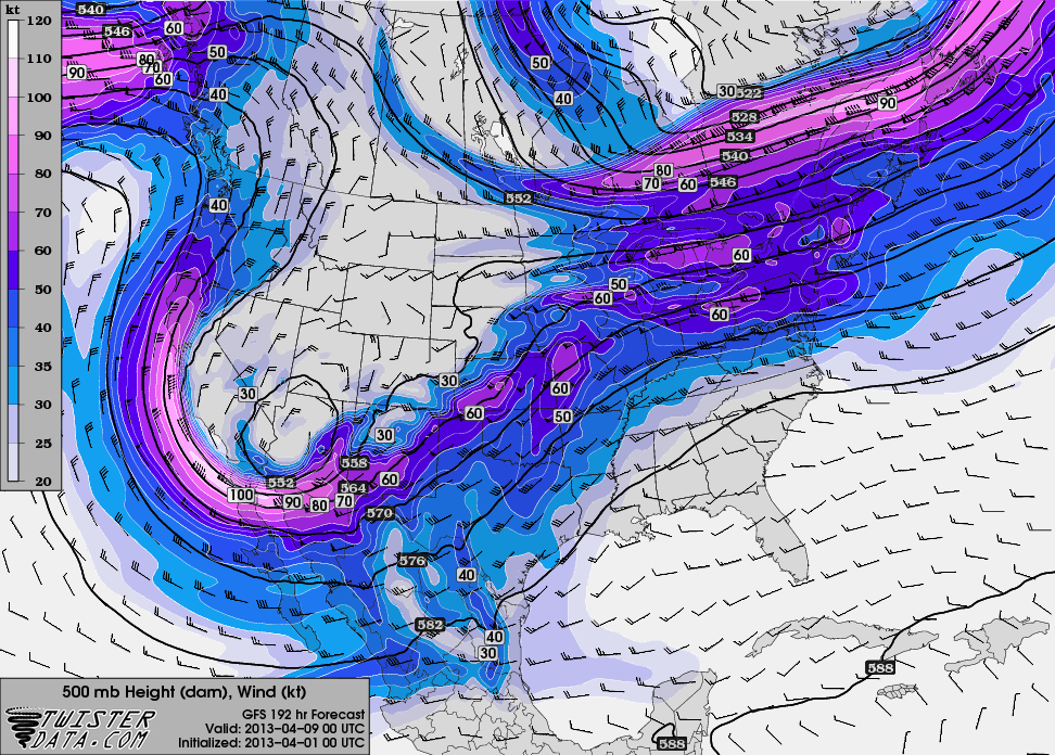 The ECMWF broadly agrees. The first map (click to enlarge), initialized today at 00Z, compares the 168 hour forecasts for GFS and Euro heights for Sunday evening, April 7 (00Z April 8). The second map, from TwisterData, depicts the GFS 24 hours later at 7 p.m. CST.
Maybe not a poster child for negative tilting (though the 6Z run changes that), but it could signal the breaking of the Champagne bottle against the hull of chase season 2013. The details will fill themselves in as the forecast hour narrows down. Right now, this is a hopeful sign for storm chasers. Winter may still have a gasp or two left, but we’ve made it through, and change is on the way.
Prior to that, the models point to a shortwave moving through the upper Midwest next weekend. Will it have sufficient moisture and instability to work with near the warm front? Good question; we’ll find out, assuming subsequent model runs don’t wash it out. So far it has shown up consistently. For those of us who live northeast of Tornado Alley, it’s worth keeping an eye on.


Everything is looking good for April 8th/9th…hopefully it stays that way!
Nice updates to the website. And thanks for the link to the ECMWF Forecast Model page. I did not know about that website. Its nice to have several ECMWF resources on a single page.
Thanks, Chris! Just for kicks, last night I ran the 00Z GFS sounding data for Lawton, OK, through RAOB and got this:
I don’t know what the latest data shows, but however this system finally plays out, Monday at least seems like a good bet, and perhaps Tuesday.
I can thank my sweetheart, Lisa, for the great new look and the new ease and functionality of Genesis for WordPress. Lis is a WordPress guru, absolutely amazing, and I am blessed to have her share her expertise with me. As for the ECMWF, Mike Geukes has done an incredible job of aggregating ECMWF sites, including San Jose and plenty of others as well. The guy is a fount of weather resources, from forecasting models to statistics.
That sounding looks real nice! Are you taking a trip down south if everything plays out? I have to imagine it would be hard to pass this up.
It does indeed look great. But the last couple of model runs, notably the 12Z, have blown it to pieces. That’s just how it is this far out with a big system. You can tell something is coming, but exactly where is anybody’s guess.
That is for sure. A lot can change in the next 7 days, but the chances do look good that some sort of severe weather even will occur. I might have asked you this last year, but what software did you use to get that sounding? Thanks.
I used RAOB, Chris. It’s absolutely amazing–like Bufkit on steroids, and much easier to use. You’ll see it advertised to your right in the sidebar. Click on the image to go to the site, or just click here. You might also want to check out this interview that I did a year or so ago with RAOB’s creator, John Shewchuk. John is brilliant, super-nice, and gives impeccable support.
Greatly appreciate it. Thanks!