Enter March: No Repeat of 2012

March 2 2013 GFSMarch 2013 won’t be making anything like last year’s brutal grand entry. For residents of the Ohio valley, that is a good thing. On March 2 a year ago, unseasonably springlike conditions fostered an outbreak of tornadoes, including the violent Henryville, Indiana, tornado that my friend Bill Oosterbaan and I intercepted north of Palmyra.

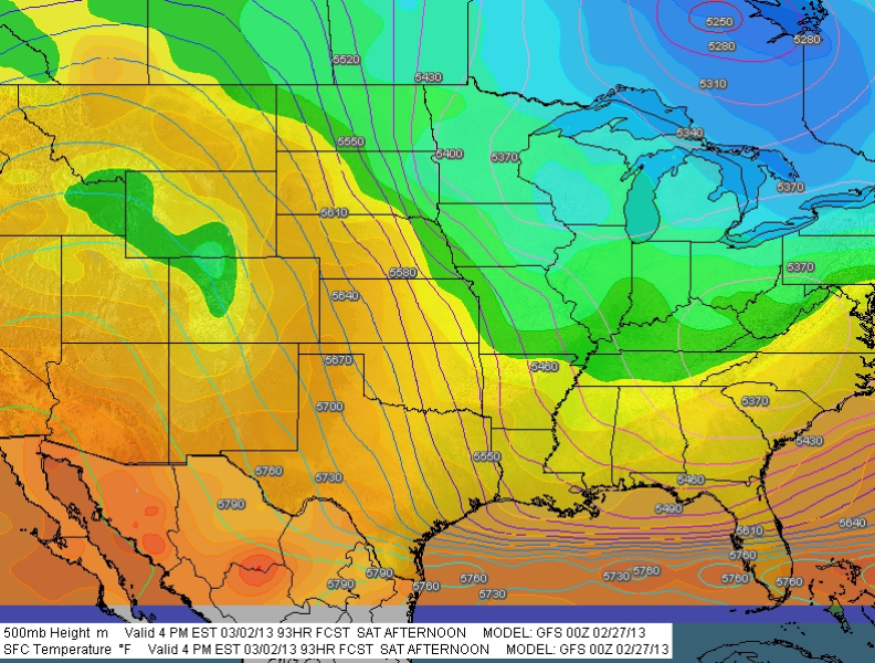
This March’s arrival portends nothing like that. One look at the map (click to enlarge) will show you that conditions are quite different from last year. The model is today’s (February 27, 2013) 00Z run showing the 500 mb heights and surface temperatures for March 2 at 21Z. With a ridge dominating the western half of the CONUS and cold Canadian air sitting atop the Great Lakes, the picture doesn’t even remotely resemble the 2012 scenario that sent storm chasers scrambling for their gear. A few days prior to the event–that is, right about now–we were casting anxious eyes on the embryonic system with the sense that northern Dixie Alley was in for it.

I’m frankly glad that a cooler, more quiescent opener is in store for the 2013 meteorological spring. I will be pleased to get more snow, and I hope the Midwest and Great Plains get a few more good, solid dumpings before storm season arrives in earnest. Storm chasing aside, the more moisture, the better for regions that have languished under severe drought. As inconvenient as the recent blizzard was for west Texas, I’ll bet the folks in Amarillo were mighty glad to get that much snow. I hope they get more, or just water in abundance in whatever form it takes.

This March may be entering on the cold side, at least here in Michigan, but that’s okay. It is March, the month of transition. I’m equipped with a “new” used car, a 2002 Toyota Camry that is drum tight and ready to take me wherever I need to go in order to see tornadoes. It won’t be long now. See y’all under the meso!

Winter Storm in West Michigan

I don’t normally let so much time elapse between posts, but…

  • •  I’ve been hugely focused on an editing project; and
  • •  I sprained my ankle a few weeks ago, greatly curtailing my activities; plus
  • •  this has been an abnormally warm, largely snowless winter thus far; and so, adding everything together
  • •  I haven’t had much to write about.

But that has changed with the arrival of this latest winter storm, which I am live-streaming on iMap even as I write. Here’s what it looks like on the radar as of around 9:20 a.m. (Click on the image to enlarge it.) A little farther down the page is a corresponding view from my balcony here in Caledonia, Michigan. Let’s put it this way: it’s not very pleasant outside.

The Grand Rapids weather office has this to say:

...WINTER WEATHER ADVISORY REMAINS IN EFFECT UNTIL 7 PM EST THIS
EVENING...

HAZARDOUS WEATHER...

 * SNOW WILL CONTINUE TO FALL ACROSS THE AREA INTO THIS MORNING
   BEFORE TAPERING OFF. SOME LOCAL POCKETS OF HEAVIER SNOW WILL BE
   POSSIBLE AT TIMES.

 * STORM TOTAL SNOW ACCUMULATIONS OF 3 TO 6 INCHES ARE EXPECTED
   THROUGH 7 PM FRIDAY EVENING...WITH LOCALLY HIGHER AMOUNTS
   POSSIBLE.

 * SOME WIND GUSTS OF UP TO 30 MPH WILL CAUSE SOME BLOWING AND
   DRIFTING SNOW LATER TODAY.

The updated aviation forecast includes this addendum:

AREAS IN THE WARNING WILL SEE 5 TO 8 INCHES WITH SOME AMOUNTS UP TO 10
INCHES POSSIBLE.

Latest station ob at GRR shows a temperature of 27 degrees. That’s not at all horrible for this time of year in Michigan. What we’re getting is actually standard fare. But that’s not to make

light of it. Conditions certainly aren’t balmy, and a 20-knot northwest wind doesn’t help. This is a great day to be inside. It’s times like now when the benefits of working at home become strikingly apparent. No scraping ice off the windshield of my car. No driving down icy roads. Just a manuscript to edit while catching glimpses of the birds swarming the feeder against a backdrop of windblown snow.

Life’s good things aren’t necessarily pricey. I’m content with a cuppa joe, a warm apartment, my work in front of me, and a pretty landscape outside the window with the snow piling up. From the looks of it, we’ve got around four inches right now. Bring on the rest of it. I’m not going anywhere.

Winter Arrives in Michigan

Today is the first day of meteorological winter. Since my post on this date last year explains why, from a weatherly perspective, winter begins on December 1 instead of December 22, there’s no need for me to re-pave that same road here.

However, the weather today is quite different from what it was a year ago. Back then, we were getting a pretty good dusting of lake effect snow, and I included a radar capture in that day’s post to show what we could expect for the next four months. In contrast, today has dawned clear-skied, and this bright sun streaming through the sliding glass door directly onto my face is forcing me to squint with my left eye and prompting me to fetch my broad-brimmed Tilley hat directly after I dot this sentence.

There, hat installed. Much better. Now, what was I saying? Oh, yeah … unlike last year’s snowy opener here in West Michigan, this winter is stepping in with a smile. But that signifieth nothing. Two days ago, on November 29, the state got its first taste of accumulation in a belt that slanted, roughly, from Coldwater up toward Saginaw.

Here in my little town, what was initially forecast to be at least an inch of snow turned out to be just an errant flake or two. The payload didn’t miss us by much, though; just a few miles to the east, the snow came down. Last night, driving home from a practice session with my sax in Clarksville, I noticed that the fields were covered. The satellite photo to your left shows what the actual accumulation looks like from above. (Thanks to my friend Mike Kovalchick for initially posting this image in Facebook.)

Cold temperatures are becoming the norm. From here on, the forties will be a high, and anything in the fifties, a gift. We’re in that transition zone between rain and snow, with snow becoming the dominant form of precipitation. More of it is in the forecast for this week, and I don’t doubt that by the time the winter solstice arrives on December 22, meteorological winter will already have settled in with a smug grin on its face.

Today, though, the sun is shining, and while this isn’t exactly T-shirt weather, I’ll take it. Time to sign off and get the rest of the day rolling.

——————————

PS  You might also enjoy reading my explanation of the meteorological seasons in  “Winter Comes Knocking,” posted yesterday in my new blog, Fox’s World.