August Tornado in Macomb: A Lake Breeze Landspout

Monroe TornadoOn Wednesday afternoon, August 20, 2014, a small tornado spun up beneath a seemingly garden-variety summer thunderstorm and did EF0 damage in Lennox Township on the eastern side of the state. I first became aware of it courtesy of a Facebook post by fellow Michigan-based storm chaser C. J. Postal. He wrote, “I give up. You win, Michigan.” Underneath was a photo of  an unmistakable, nicely shaped funnel cruising over the treeline.

My first thought was, What does he mean? The photo couldn’t have been taken in Michigan. No way. It simply wasn’t tornado weather–no ripping jets, no curved hodographs, just weak westerly winds and, here on the west side of the state, beautiful, cloudless skies. Over on the east side, the radar showed just a scattering of small red zits around the thumb and down by Ann Arbor: bland, pulse-type storms capable of squeezing out a few bolts but certainly not a tornado.

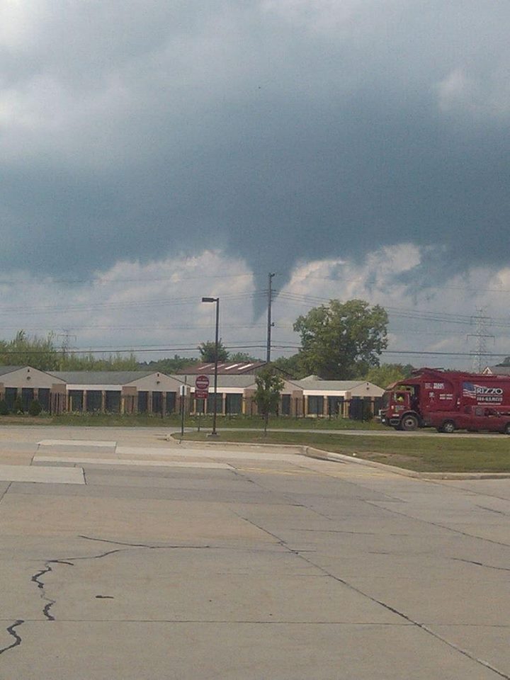
Yet as you can see from the photo,* one of them did spin up a tube. The National Weather Service logged the following report.

A BRIEF EF0 TORNADO TOUCHED DOWN AROUND 204 PM ON PLACE ROAD BETWEEN 29 MILE AND 30 MILE ROAD IN LENOX TOWNSHIP. PATH LENGTH WAS ESTIMATED TO BE 0.25 MILES WITH A PATH
WIDTH OF 100 YARDS. WIND SPEEDS WERE ESTIMATED TO BE 75 MPH. FIRE OFFICIALS REPORTED SEVERAL TRAILERS BEING BLOWN OVER AS WELL AS A ROOF TO A GARAGE BEING TORN OFF.

What the heck happened?

Michigan happened.

Seriously. Not only does this state not get tornadoes when conditions look ripe for them, but it does get them when no one expects them. It happened a couple years ago in Dexter. It happened last month just a few miles from me in Cutlerville. And now, two days ago, it happened over near Macomb.

Wind profiles were unimpressive. Bulk shear was negligible. About the only things in place, as I recall, were adequate surface-based CAPE and moisture, but this was by no means supercell weather. “Severe” just wasn’t in the picture.

However, one easily overlooked element unique to the Great Lakes probably was present and might well have been the culprit. That ingredient? The onshore breeze blowing off of Lake St. Clair.

Twenty-six miles long and twenty-four miles wide, with 430 square miles of surface area, the lake is the largest body of water in the Great Lakes region after the Great Lakes themselves. It is easily large enough to generate its own lake breeze. On its western shore, that breeze is an easterly breeze which, backing against an overall westerly wind regime, can enhance low-level helicity or even produce it when none would otherwise exist.

That’s my theory, anyway, and I think it holds true not just for Lake St. Clare but even moreso for the western sides of Lakes Huron, Erie, and Michigan, where the lake breezes blow inland from the east. Storms moving into such an environment may, under the right conditions, get just the added low-level twist they need to turn an ordinary updraft into a tornado.

That, I believe, is what happened last Wednesday. The mechanism was probably that of a landspout. It certainly wasn’t that of a supercell thunderstorm. None of the storms I saw on the radar that day looked capable of producing a mesocyclone; they were non-severe little blips on the radar. But they were surface-based. And that combination of an updraft with preexisting vertical vorticity evidently did the trick.

I’ve seen enough other examples of storms in this state that went tornadic, or at least developed rotation, as they approached the eastern coastline to think that the lake breeze plays a role in a good percentage of cases. No doubt the same holds true for the northern Chicago area north up into Wisconsin inland from Lake Michigan.

What I’m saying may be nothing new to NWS meteorologists, but I don’t recall ever seeing it discussed. Then again, I rarely read KDTX’s forecast discussions, so maybe that’s why. I’m a KGRR man, but here in West Michigan, while our westerly lake breeze creates convergence, I doubt it contributes to helicity in the same way as the easterly breezes coming off of Lakes Huron, Erie, and St. Clare.

I’ve never seen the lake breeze’s possible role in storm rotation and tornadogenesis discussed to any great extent, and I think it merits recognition as a uniquely Great Lakes phenomenon. So I’m throwing it out here, with the caveat that I’m just an amateur forecaster, not a trained meteorologist. It would be great to get the thoughts of professional forecasters as well as other Great Lakes storm chasers who have considered how the easterly lake breeze may sometimes enhance storm severity.

———————-

* I would like to credit the photographer, but having exercised due diligence, I’m unable to locate that person. If you took the picture, or if you know who did and how I can reach them, please contact me.

March 15, 2012, Dexter and Lapeer, Michigan, Tornadoes

Thursday’s tornadic supercells in eastern Michigan took a lot of people by surprise–NWS and media meteorologists, the SPC, storm chasers, and certainly me. Nothing about those anemic mid- and upper-level winds suggested the potential for even weak tornadoes, let alone significant ones. But there’s no arguing with Nick Nolte’s fabulous footage of the Dexter tornado, and certainly not with the damage that storm did as it swept through the town. It has been rated an EF-3, the most damaging of the three tornadoes reported on March 15, 2012. Second in impact was a tornado that struck farther north in Lapeer, causing EF-2 damage; and finally, an EF-1 tornado in Ida.

Like every other chaser in Michigan whom I know, I had no plans for chasing storms Thursday. True, temps were in the 70s and dewpoints in the 60s; MLCAPE was in the order of 3,000–3,500 J/kg; and the hodograph looked curvy.

But curvy alone isn’t supposed to cut it, not when the dynamics are as puny as they were: winds around 20 kts at 850 mbs; 20–25 kts at 700 mbs; and 25–30 kts from 500 mbs on up to around 26,000 feet, where they finally began to make incremental but hardly impressive gains. The storms that formed should have been popcorn cells that quickly choked on their own precipitation. But they didn’t. At least some of them became classic supercells that lumbered across eastern Michigan at around 15 miles an hour, spinning up strong tornadoes.

I was sitting in my living room editing a book manuscript shortly after 5:00 when I happened to glance out the window and saw some impressive, well-formed towers to my southeast. “Dang!” I thought. “Those look nice!” My second thought was to grab my camera and snap a few photos. After all, thunderstorms just aren’t something you normally see on March 15 in Michigan, let alone such muscular-looking ones. You can view one of the three shots I took–the last one, time-stamped 5:22 p.m.–at the top of the page. (Click on the image to enlarge it.)

Curious, I took a look at GR3. I’d been glancing at it off and on as the afternoon progressed, watching a small squadron of cells pop up across southern and eastern Michigan. They resembled something I might normally see in July or August. But now, one of them looked different–so unexpectedly different that I had a hard time believing what I was seeing. South of Howell and northwest of Ann Arbor, the most vigorous-looking storm of the bunch had transformed into an unmistakable supercell–a regular flying eagle with a little pinhole BWER in the hook.

Where the heck did that come from, and why on earth was it there? Pinch me, I must be dreaming. I switched to SRV, and sure enough, there was a couplet, and not just a weak one, either. A pronounced couplet.

A scan or two later, the storm was continuing to develop. The pinhole had disappeared, and the supercell now had a classic hook. On radar, it looked as nice as anything you could hope to see out West in May–only this was Michigan in mid-March.

Surely the winds had to be better than I had been led to believe. One way to find out. I pulled up the VAD wind profiler at DTX. Ummm … well, okay. Nothing at all remarkable there. Maybe, given the curviness, enough bulk shear to organize the storm. Obviously that had to be the case; the evidence was staring me in the face, along with a couplet which hinted at the tornadic action that was presently occurring. The last screen capture, just below and to your right, shows both the couplet and the VAD. Enlarge the image, zoom in on it, and you can see for yourself just how meager the winds were and why one would expect storms forming in that environment to drown themselves in their own tears.

While I was glued to my radar in Caledonia, across the state storm chaser Nick Nolte was hot on the storm and videotaping the tornado that eventually hit Dexter. After getting out of work for the day, Nick had noticed the storm popping near where he lives. Grabbing his gear, he took off on what turned out to be one of the most serendipitous chases any chaser could hope for.

Nick got some fantastic footage of the Dexter tornado. Congrats, Nick–you really nailed it! Rather than steal Nick’s thunder by embedding his YouTube video here, I’m going to simply redirect you to his site and let you hunt it up there.

I’ve viewed some other footage beside Nick’s that demonstrates a particularly noteworthy aspect of the Dexter tornado, and that is its breakdown into helical vortices. I’ve seen only one other video that demonstrates this helical structure so clearly, and that is the famous KARE TV helicopter video of the July 18, 1986, Minneapolis tornado. The Dexter footage isn’t as dramatic, but it nevertheless depicts the helical effect with stunning and captivating clarity. Nick’s video captures it as well toward the end of his clip. It’s really amazing to see.

Unfortunately, the Dexter and Lapeer storms did considerable damage. If there’s a bright side to their human impact, it’s that no one was killed or seriously injured.

What turned yesterday’s anemic setup into a significant tornado-breeder? A weak upper-level impulse provided the needed lift to spark the storms, but it doesn’t explain why some of them developed into tornadic supercells, given the lackluster mid- and upper-level winds. I’m no expert, but I’m guessing that the unseasonably high CAPE is what did the trick. I suspect it took what was present in terms of shear and helicity and amplified it, in effect creating the Dexter, Lapeer, and Ida storms’ own mesoscale environments–ones conducive to tornadoes.

Of course, similar scenarios typically provide no more than single-cell and multicell severe storms. But then, yesterday was an anomaly in some significant ways. After all, this is Michigan, and it’s only mid-March. When CAPE of that magnitude shows up in the midst of unseasonably high dewpoints, it appears that all bets are off.

ADDENDUM: Lest you should miss reading the comments, check out this satellite loop from Thursday. You can see the storms exploding along an outflow boundary pushing west-northwest from Ohio, and other storms firing along a cold front dropping southeast. Two boundaries, and they actually appear to collide around Saginaw. The OFB accounts nicely for convergence and low-level helicity. Thanks to Rob Dewey for sending me the link.