Are the Great Plains About to Open for Business?

ECMF-GFS H5 fcst 0408013Last year’s abnormally balmy March opened for storm chasers with a lion-like roar on the 2nd with a deadly outbreak of tornadoes along the Ohio River southward. But from then on, with the exception of April 13 and 14, the season dwindled into a pathetic, lamb-like bleat.

This March has been the polar opposite, and I do mean polar. Many chasers have been champing at the bit due to a wintry pattern that has simply refused to let go. But that may finally be about to change, and April may be the month when this year’s chase season starts to howl. For the last several days, I’ve been eyeballing a large trough on the GFS that wants to invade the Great Plains around April 8, shuttling in Gulf moisture and also suggesting the possibility of warm-front action farther east on the 9th.

GFS H5 fcst 00z 040913
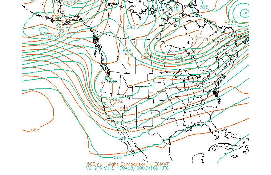
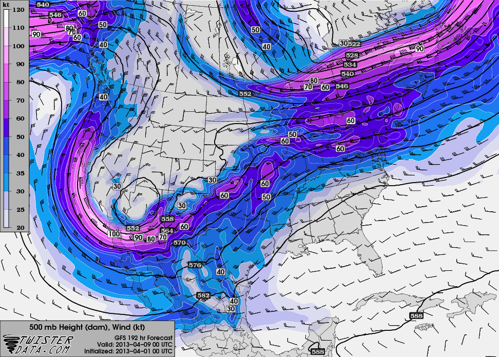
The ECMWF broadly agrees. The first map (click to enlarge), initialized today at 00Z, compares the 168 hour forecasts for GFS and Euro heights for Sunday evening, April 7 (00Z April 8). The second map, from TwisterData, depicts the GFS 24 hours later at 7 p.m. CST.

Maybe not a poster child for negative tilting (though the 6Z run changes that), but it could signal the breaking of the Champagne bottle against the hull of chase season 2013. The details will fill themselves in as the forecast hour narrows down. Right now, this is a hopeful sign for storm chasers. Winter may still have a gasp or two left, but we’ve made it through, and change is on the way.

Prior to that, the models point to a shortwave moving through the upper Midwest next weekend. Will it have sufficient moisture and instability to work with near the warm front? Good question; we’ll find out, assuming subsequent model runs don’t wash it out. So far it has shown up consistently. For those of us who live northeast of Tornado Alley, it’s worth keeping an eye on.


Gulf of Mexico Sea Surface Temperatures and the 2013 Storm Season

Every year, the same question inevitably comes up: What is the upcoming tornado season going to be like?

The only truly definitive answer is no definitive answer. No one knows for sure till spring arrives, and the best any of us can go by are guesses, some better informed than others. I’m prepared to offer a few thoughts on the matter, but that’s all they are: thoughts, sheer speculation, items for consideration, not convictions or predictions; and they are those of a layman, not a professional meteorologist or a climatology expert.

With that caveat clearly stated,  I have some hopes that this year will offer a few more “big” chase opportunities than 2012. True, the horrible drought that put the kibosh on setups last year after April 14 hasn’t gone away, nor does it show any sign of letup. And without any evaporative boost from moist earth or vegetation, dewpoints are apt to mix out in the Great Plains. That’s no news to anyone.

ENSO 2013 SST Forecast MapsHowever, I have noticed that sea surface temperatures in the Gulf of Mexico are above normal, and the CPC’s (Climate Prediction Center) ENSO maps forecast them to remain so. Below are the most recent maps, current as of January 28,  covering the period from February through June, 2013. Click on the image to enlarge it. At the top right, you’ll see the Gulf of Mexico shaded in orange, indicating an average temperature deviation of 0.5 to 1.0 degree Celsius above normal closer to shore, and normal farther out.

These are coarse approximations, of course. But you can drill down a little further by checking out current buoy observations against average station temperatures, courtesy of the NODC (National Oceanographic Data Center). Below is their table showing current station obs for February 3 to the far left; and, extending to the right of the obs from some of the stations, average normal monthly temperatures.* A quick glance will tell you that SSTs were well above average for this date, and in light of the ENSO maps, it seems reasonable to think that they will remain so. In fact, today’s and yesterday’s readings seem to be about a month ahead of the game, though granted, those are just two days, and there are bound to be plenty of  fluctuations through the rest of the month.

NODC Current and Avg SSTs

What I feel safe in saying is that the overall higher SSTs in the Gulf of Mexico suggest a better moisture fetch than last year’s generally anemic return flow. Maybe the Midwest will benefit most from it, and I for one won’t weep if there are some decent setups closer to home. I can’t think of a better place to chase storms than the flatlands of Illinois.

However, it seems to me that Tornado Alley also stands a better chance of action as well, provided the polar jet cooperates this year by showing up farther south, where richer incursions of moisture can get at the energy. Neutral conditions that favor neither El Nino nor La Nina this spring strike me as more promising than last year’s La Nina.

I weigh the above information against recent (i.e. January 29) CPC drought maps, which don’t paint the rosiest of pictures for most of the Great Plains but look good farther east and in the northern plains. Below is the most current drought monitor maps, released January 29; and the drought outlook, valid from January 17 through April 30.

CPC Drought Info 1-29-13

Again, I’m neither a climatologist nor a meteorologist, just someone who likes to piece information together and see whether it bears out. Maybe it won’t. My original hunch was that, because of the drought, our storm season would be a repeat of last year’s, starting early and dying young. And maybe that’s the way it will be. But if I correctly understand the implications of warmer-than-normal GOM temperatures, it seems to me that this year could be at least modestly more active than last year’s abysmal storm season and might even hold a few surprises. It certainly can’t get any worse.

_______________

* Station observations shown are for the western Gulf. Obs for the eastern Gulf are also available at the NODC site.