Great Lakes Waterspout Season Is at Hand

Now is the time of year when waterspouts start putting in an appearance on the Great Lakes. I had largely forgotten about spouts until a few days ago when my friend and fellow weather weenie Mike Kovalchick mentioned them in an email. Bing! A light blinked on in my head: That’s right! Waterspouts!

I’ve never seen a waterspout. But then, until last year about this time with my buddy Kurt Hulst, I’d never made a point of going out after them. Kurt and I busted that day, but maybe this year I’ll get lucky, provided I increase my chances by taking more opportunities to chase spouts.

I have zero experience forecasting waterspouts. Thankfully, there’s a snappy little graph called the Waterspout Nomogram that simplifies the process. Developed by Wade Szilagyi of the Meteorological Service of Canada, the Waterspout Nomogram provides a quick visual aid for determining when certain critical parameters are in place for four different classifications of waterspout: tornadic, upper low, land breeze, and winter.

The tornadic variety is self-explanatory, and any storm chaser with some experience making his or her own forecasts should have a good feel for when that kind of waterspout is likely. Mike favors the 500 mb cold-core, closed low setup, which to my thinking may be a variant of the first in producing low-top supercells. The remaining two, land breeze and winter, seem to involve different dynamics. For all the waterspout categories, one of the constraints is that for spouts to occur, winds at 850 mbs have to be less than 40 knots, something I find particularly interesting in the case of supercell-based waterspouts.

In any event, I’m hoping that this year is my year to finally witness a spout or two. Michigan chasers and weather weenies, it’s time to pay attention to the marine forecasts. The “second season” can include action right along the lakeshore even when nothing’s popping anywhere else. Make sure you bring your shotgun just in case a waterspout gets too close for comfort (written with a wink and a grin).
May 22 South Dakota Tornadoes: Part 3

There’s nothing funny about finding yourself trapped at the end of a dead-end road with multiple tornadoes bearing down on you. It’s not a scenario one anticipates when heading out on a chase, but it’s the one my chase partners Bill and Tom Oosterbaan, Mike Kovalchick, and I found ourselves in, along with seven other vehicles full of chasers, last Saturday in South Dakota.

Up until the moment when the road we were on ended abruptly at the edge of a farmer’s field, we were simply performing a routine maneuver: select an escape route and take it when the storm draws near. We and the other chasers had chosen 130th Street east of CR9 as our best eastbound option. It looked good on both DeLorme Street Atlas and Microsoft Streets & Trips: a nice through road connecting with 353rd Avenue three miles away. It was a perfectly logical choice, and things would have proceeded without incident had the maps been accurate.

What the maps didn’t show was that a farmer had recently plowed over the road, converting it to a field. We made that delightful discovery two miles down. The road had already begun to degrade, presenting us with a couple mudholes which Mike’s Subaru Outback plowed through without a problem. But the field was a show stopper. Suddenly, poof! No road. On an ordinary day, this discovery would have been an inconvenience. With tornadoes breathing down our neck, it was horrifying.

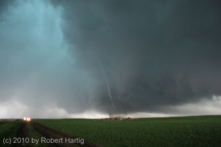
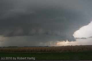
But I’m getting ahead of myself. Let me backpedal a bit to set the stage. After stopping to enjoy the eminently photogenic fourth tornado that followed the beastly Bowdle wedge (see previous post), the four of us headed north to CR2/125th St., then turned east. The storm was morphing into a high precipitation supercell (photo at top of page). We watched it drop a couple more

rain-wrapped tornadoes. Then it pulsed, catching its breath and gathering energy for the next round.

Dropping south down CR9, we pulled aside by a roadside pond to grab a few photos. The updraft area was a couple miles to our west, and while it didn’t presently seem to be tornadic, appearance can be deceptive. The cloud base was low, nearly dragging on the ground, with suspicious lowerings forming and dissipating. It looked like it could drop something at any time, and chances are it was even then producing random, momentary spinups.

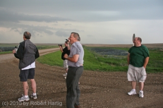
Hopping back into our vehicle, we proceeded farther south to the corner of 130th Street, where we once again parked. Here, we bumped into chasers Ben Holcomb, Adam Lucio, Danny Neal, and Scott Bennett. We had last seen these guys at a truck stop in Murdo; now here they were again, along with several other vehicles, all converging out ahead of the meso in the middle of nowhere. In the photo, left to right: Tom, Ben, Bill, and Scott.

As the storm drew closer, Tom pointed out that rotation was beginning to organize overhead. It was time to skedaddle. Back into Mike’s Outback we clambered, with Tom at the wheel, and headed east down 130th Street.

At this point, it’s important to bear in mind that every vehicle that showed up at our location had independently pre-selected 130th Street as a valid escape route. What followed did not begin as a desperate dash for safety, but as a calculated, run-of-the-mill tactical maneuver informed by commonly used mapping software. Most of the people involved were experienced chasers, some of them veterans. The reasoning behind our road choice was sound. Unfortunately, the information we based it on was not.

Thus it was was that two miles down the road, suddenly there was no road. At the front of a string of other chase vehicles, we were the first to make that

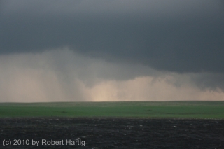
discovery. Tom turned around and started heading back, yelling to the next vehicles that the road was out. It was then that a tornado suddenly materialized in the field maybe half a mile to our west, just south of the road. It was a regular drill press, spinning furiously as it made its way toward us. It finally crossed the road and headed east-northeast a few hundred feet away, but even as it did so, another, thicker funnel snaked to the ground at roughly the same place where the first one had formed. I don’t think most people saw this second tornado; it moved toward us briefly, kicking up dirt, then dissipated, though I could still see swirling motions in the rain bands where it had been.

In the photo, besides the rope tornado, notice the lowerings farther back. These meant business. We were at the eastern edge of a broad area of rotation that was dropping not suction vortices, but multiple tornadoes of various sizes, intensities, and behaviors. In my observation, these were NOT moving in cyclonic fashion around a common center, but east with the parent storm–and straight at us.

A large cone appeared to the west, which, gathering strength, moved through the field to our north. By this time, it was clear that we were in a truly lethal situation, cut off to the east by a dead-end road and to the west by tornadoes.

Windy? Hell yes it was windy. The inflow was cranking like a sumbitch, and from the looks of things, it was only going to get worse. I looked around for a ditch, but there was absolutely nothing that could have offered protection. I noticed a stout post a few yards away and contemplated lying flat and wrapping my arms around it. Tom had the same idea. Mike was eyeballing a large pile of stones a hundred yards away, thinking it might provide some shelter, but it was too far a dash with no time left to make it in.

It was at this point that UK chaser Nathan Edwards drove off the road and began heading south into the field. He told me later that he was simply attempting to clear some room for other vehicles to move forward, hopefully edging just a little bit closer to out of harm’s way, but Nate’s move prompted the rest of us to follow. In a last-ditch gamble, the entire entourage of chase vehicles began fleeing south along the fence boundary.

The tornadoes were close. Really, they were on top of us. I watched as two funnels formed a hundred yards west of our vehicle, twisting around each other and moving toward us like the “sisters” in the movie “Twister.” The rain curtain was full of swirls and braids. And what was particularly unsettling was that, as we dashed across the farmland, the business part of the storm seemed to be expanding, reaching out after us. For a mindless force of nature, this storm was displaying as close as you can get to malevolent intent.

It dawned on me that if ever there was a time to pray, and pray hard, this was it. I’m a Christian–a bit of an iconoclast in that I don’t buy into a lot of Western church culture, but I love Jesus, I’m serious about following him, and conversing with God comes naturally to me. I don’t mean just in a pinch, but as a lifestyle. You can bet that at this point, I began praying most intensely.

A couple hundred yards in, we encountered a wet area and ponding and were forced to forge our way into the cultivated field. It was there that the storm caught up with us in earnest. End of the road for real. There was nothing left to do now but hunker down, pray, and hope.

Obviously I’m here to tell the story. All of us are, every last person. That none of us were killed or seriously injured, or for that matter sustained  so much as a scratch, is in my book God’s love and mercy, pure and simple. A video clip by Adam Lucio shows a tornado forming right in our midst, not ten yards from one of the vehicles. I never saw it, but Adam’s video is conclusive and sobering. We came so close, so very close. The rear flank downdraft alone had to have been in the order of 100 miles an hour. Yet nothing truly bad happened to any of us.

Some may call that a lucky draw; I call it answered prayer. Believe what you will, but there’s more to the story, an experience uniquely mine that I’ve shared with only a couple people so far. Look for it in my upcoming, final post concerning this incident. Whatever you make of it, I think you’ll agree that it’s uncanny.

That’s it for now, but this story continues. What followed with the farmer who owned the field, the sheriff and police, and other locals is for another episode, and it’s still not entirely resolved.

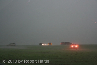
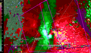
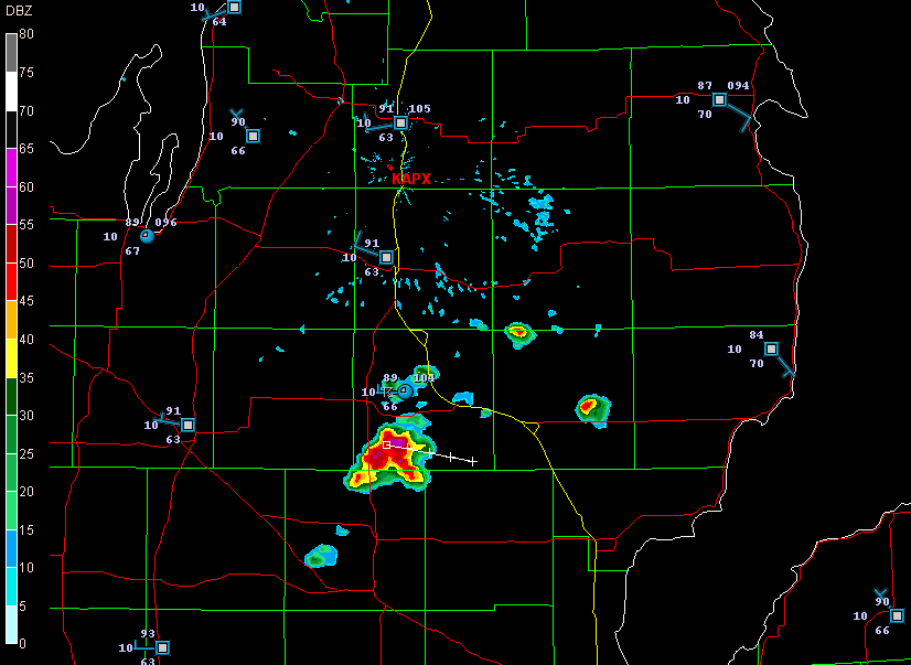
I’ll leave you with two images, both taken when the worst of the storm had just moved past us. One shows some of the vehicles getting slammed by the still-hellacious RFD. The other is a GR3 radar grab of the rotation and our location relative to it, shown by the circular GPS marker.

With that, I’ll sign off. Keep an eye out for parts four and five.

Major Winter Storm in Progress out East: Big Snow South of the Big Apple

no images were found

Which version of snowfall totals do you prefer–the NAM on the right, or the GFS, shown below? (Click images to enlarge.)

If you live out east, the question is purely academic. I doubt that you much care which forecast model is the more accurate, because either way, you’re going to be sitting under a ton of snow by tomorrow. That much is no secret. While the forecast models shown here are for 00Z Saturday night, the show has already started.

Farther down the page, you can see a level 2 radar grab from Sterling, VA, taken shortly after 10 p.m. It’s much prettier to look at than the picture

no images were found

that is unfolding over the nation’s capitol as I write in the form of heavy snow, freezing fog, mist, freezing rain, blustery winds, blizzard conditions–just about every kind of winter weather you can throw at one area in the space of a few miles as temperatures drift from below to above freezing.

The current Baltimore forecast for tonight and tomorrow reads as follows:

Tonight: Snow and areas of blowing snow. The snow could be heavy at times. Low around 29. Breezy, with a east wind between 16 and 23 mph, with gusts as high as 37 mph. Chance of precipitation is 100%. Total nighttime snow accumulation of 15 to 21 inches possible.

Saturday: Snow and areas of blowing snow. High near 29. Blustery, with a north wind between 18 and 22 mph, with gusts as high as 37 mph. Chance of precipitation is 100%. New snow accumulation of 4 to 8 inches possible.

no images were found

Ugh! For once I’ll take a Michigan winter forecast over what’s being served up elsewhere. Right now my friend Kathy out there in Greenbelt, MD, is getting her clock cleaned. It’s a good night for her and her boyfriend to eschew the Washington nightlife and hunker down inside. For that matter, I doubt there’s much happening in the way of a Washington nightlife on a night like tonight.

Meanwhile, down in the warm sector, much of eastern North Carolina is under a tornado watch. The radar shows a pretty grungy-looking, non-severe, low-topped squall line that doesn’t show much likelihood of putting out anything tornadic, but it nevertheless adds to the East Coast’s overall weather ambience.

Have fun out there, kiddies, those of you who live out east. As for me, I’m going to pour me a mugful of Bell’s Amber Ale and, for once, enjoy watching the snow not fall outside my window. Gloating over such things is permissible for lifelong natives of the Great Lakes.

Crystal Ball Gazing with the GFS

Yesterday’s trough passed through pretty much as expected, without a whole lot of fanfare and certainly not with anything tornadic. So the question is, what lies ahead? Anything?

Maybe.

At least we’re not locking in under another ridge. Today is the first day of autumn, the weather patterns are changing, and the GFS and ECMWF seem to agree on a 500 mb trough affecting the Midwest over the next several days. And yeah, yeah, I know it’s just reading tea leaves, but here are a couple 132-hour GFS maps for next Sunday at 00Z. At the risk of stating the obvious, click on the images to enlarge them. The first shows sea level pressure (shaded), surface wind barbs, and 500 mb height contours.

The second map shows 500 mb winds (shaded) with wind barbs, and 300 mb wind contours.

The big question mark may be moisture. But this far out, it’ll be nice if that even matters by the time Sunday arrives. This time of year, living in the Great Lakes, the best one can do is hope. But there’s nothing wrong with hoping.

The Lake Breeze Zone and Severe Weather

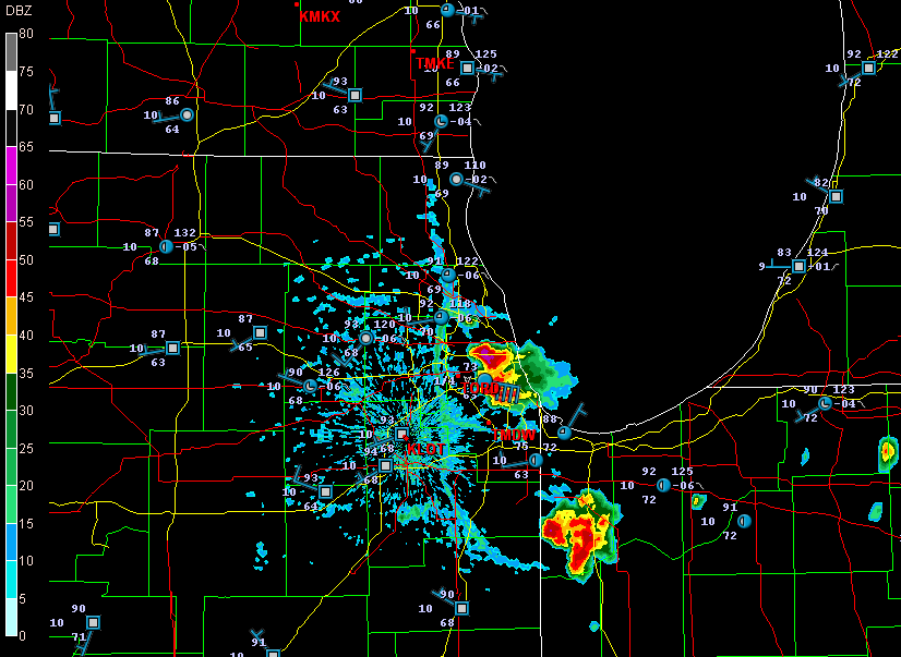
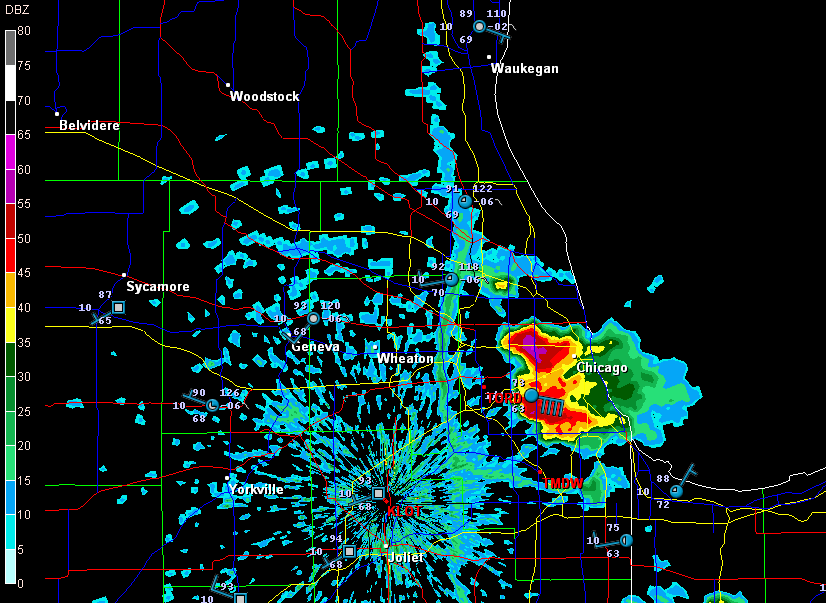
Earlier today, I opened up GR3 just out of curiosity and noticed some blobs of convection along the Lake Michigan shore by Chicago. Here are a couple radar grabs.

lake-breeze

lake-breeze1

These images interest me for several reasons, all of which have to do with a Great Lakes phenomenon called the lake breeze zone. The lake breeze zone is not a fixed area. Its boundaries are atmospheric, not geographic.

And boundaries truly are what it’s all about. Probably the most immediately noticeable feature on these radar images, besides the obvious storms, is the north-south boundary set up by the onshore breeze. It’s a great point of convergence where overall westerly surface winds butt up against backing winds from off the big lake. You can see how outflow from the storms that have fired up within the lake breeze zone interacts with the lake breeze boundary.

Another less immediately obvious by-product of the lake breeze zone is helicity. Notice how the wind barbs farther inland are all westerly, but inside the lake breeze zone, they’re easterly. Now, I’m no expert on this stuff, but I know enough to recognize the potential for localized helicity to occur even when the large-scale flow is unidirectional. During the day, strong thunderstorms can go tornadic when they encounter a backing onshore breeze near Chicago, along the Wisconsin shoreline, and along the Lake Huron and Lake Erie shores of eastern Michigan. The same can happen in the evening along Michigan’s western coast as the land cools and an offshore breeze prevails. Many times I’ve noticed the NAM and RUC showing a small sigtor centerered over Berrien County when there are no sigtors anywhere else in the region, and I’m sure this phenomenon is largely due to the lake breeze in that area.

Right now I see storms firing up farther north around Gladwin and Roscommon.

storms

A glance at the Gaylord VWP shows west winds neatly stacked from the surface on up. But look at the METARs along Lake Huron. Without much in the way of bulk shear, the storms are subsevere, just little popcorn cells. But it will nevertheless be interesting to see what comes of them as they work their way into those backed shoreline winds. You just never know.

Wedging into Tornado Season

Bill called to say that he and the crew just saw a wedge out there in western Oklahoma. The LSR gives the town of Crawford, near the Texas panhandle border, as the location.

Good for the lads–and the lass, as I understand there’s a new female member of the crew. As for me, sitting here in my La-Z-Boy sofa, nursing a chest cold and watching the radar, naturally I feel like shooting myself through the head. A wedge on a PDS day–and the show is just getting started. And I’m not there! AAAAAHHHHHH!!!!!!!

If there’s any consolation, it’s knowing that I’ve been able to make myself useful doing a little nowcasting. And it sounds like the team got some cool footage. Can’t wait to see it.

Mostly, though, I can’t wait to kick whatever is causing this blasted chest congestion and get out to take some video of my own. Tornado season 2009 is underway!

Shifting gears, last night’s gig at One Trick Pony with Francesca and Friends was a blast, even if I was feeling under the weather. Wright McCargar and I had a discussion about the impact of musicians on each other’s playing. In my experience, one bad musician can drag a whole group of good musicians down; and, conversely, one great musician can kick good players up to the next level. There’s nothing like being with really good musicians, and Francesca and her rhythm section are exactly that.

Moving back to storm chasing, it’s time for me to publish this post and then check out the radar. The storms bumping off of the dryline look to be going tornadic, and I’m thinkin’ that my buddies will have their hands full for the next five or six hours. Sure wish I was with them. But GR2AE ought to keep me entertained; maybe I can capture a few radar grabs to correspond with the photos that I’m sure will be coming back from out west.