Mesoanalysis Maps Now Available

If you’ve used the F5 Data RUC maps on my Storm Chasing page, then you’ll be pleased to know that, after a couple of days being unavailable, the maps are once again up, with some significant changes that I think you’ll like.

My initial intention when I took the maps down was to install RUC loops in their place, but I hit a snag. It’s just a temporary one, but in the meantime, I’ve decided that instead of reinstalling the original RUC maps, I’d switch to the new mesoanalysis maps that F5 has recently added to its suite of forecasting tools. I like them well enough that I may not even bother with the RUC loops. You can find plenty of sources for RUC, but not for these, so the mesoanalysis maps should give you a different and useful resource. Besides being proprietary to F5 Data in themselves, they include a couple of trademark indices that Andy Revering has formulated for capping and sigtors.

Check them out and let me know what you think. I welcome your comments.
Chasing Storms after the Concert

Bill, Kurt, and Tom are leaving tonight to chase Saturday’s setup out west. I’m staying behind to play with Francesca and Friends at the 2009 Grand Rapids Festival of the Arts. Ordinarily I’d feel a bit torn, but I have an idea that the better action will be on Sunday and–from the looks of the 12Z NAM-WRF–Monday. So when I step onto the stage tomorrow afternoon, unless between now and then a confluence between the NAM and GFS suggests that capping will suddenly no longer be an issue and Armageddon is going to break out in the Great Plains, I will be a man at peace.

But directly after the concert, I plan to pack my bags and head for the Corn Belt, where I’ll hook up with the guys and chase storms on Sunday and, if the present NAM-WRF comes at all close to verifying, Monday.

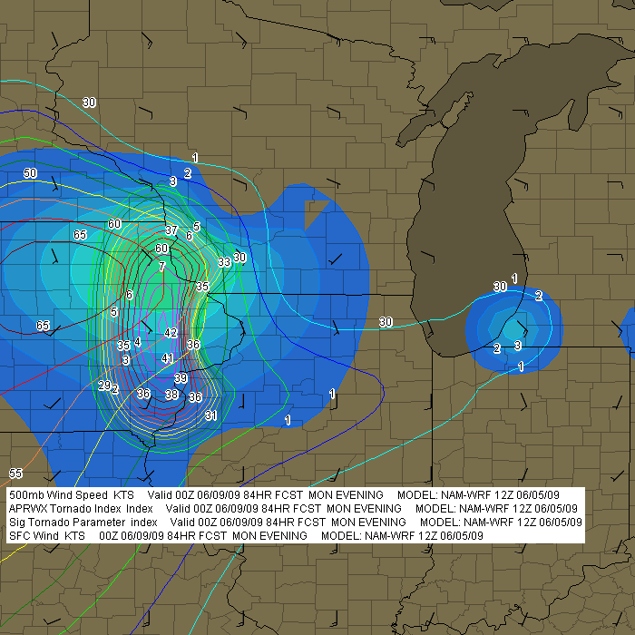
Frankly, I’m somewhat skeptical about Monday. Previous runs have consistently painted such a different scenario, with majorly veered surface winds and a unidirectional flow overall, that the 12Z’s placement of the weak surface low in eastern Iowa seems too good to be true.  Here’s an image from F5 Data showing sigtors, APRWX sigtor, surface wind barbs, and H5 wind speeds:

12Z NAM-WRF for 0Z Monday

12Z NAM-WRF for 0Z Monday (F5 Data)

Suddenly all the elements in terms of moisture, instability, and shear are lining up, along with a 7 sigtor in Iowa and even a 4 in southwest Michigan (in the usual lakeshore location, Berrien County). Makes me more than a little suspicious. But I think I can at least count on Sunday, and we’ll see whether future model runs continue to paint a rosier trend for Monday in Iowa and the Great Lakes.

So it’s play my saxophone on Saturday, then chase storms on Sunday and maybe Monday.  That’s about as nice an arrangement as I could possibly ask for–other than for this year to finally be the one where our act at the Festival doesn’t get interrupted by a hailstorm. That has happened three years in row. But I’ve got a good feeling that tomorrow is the day when we’ll finally make it through intact. That’ll be good. I’d just as soon save the hail for the day after.