Michigan in the Crosshairs Today?

Most of the time when I chase storms in Michigan, it’s as a wannabe sitting in my armchair gazing wistfully at my radar as I follow the action out west. Every once in a while, though, I get something right here in my own state that’s worth hopping into my car and driving after with my laptop and camera at hand and hope in my heart.

Today is shaping up to be such a day. It’s about time. June is upon us, and that means the peak tornado season has finally arrived for Michigan. Frankly, that term, “peak tornado season,” strikes me as glaring overkill when it comes to Michigan. But we usually have a few incidents every year, and today could be one of them. Perusing the last couple of NAM runs, including the 00Z, and running a few model RAOB soundings, I’m casting my eyes on the Flint-Pontiac area, where surface winds appear to remain, if not backed, at least southerly at 00Z tomorrow evening.

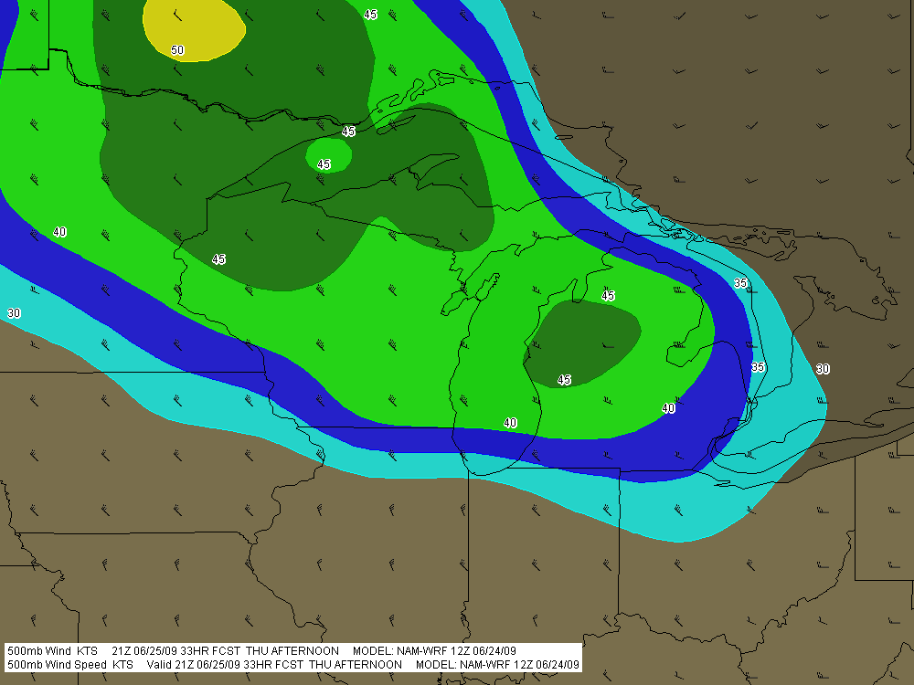
With dewpoints at or exceeding 65 degrees below a warm front draped across central Michigan, straight westerly mid- and upper-level winds with 45-50 knots at 500 mbs, and forecast SBCAPE upwards of 2,000 J/kg, there certainly look to be some decent ingredients in the vat. Insolation will be either the eye of newt that either makes the magic happen tomorrow or the missing ingredient that quashes instability thanks to blowoff from storms farther west.

no images were found

Attached are a couple soundings, the first for 23Z at Flint and the other for 00Z at Pontiac. Not bad-looking hodographs, particularly for Michigan. As you can see, the surface winds are southerly. Farther west, they veer to the southwest, though they by no means create a unidirectional scenario. Interestingly, while the STP and Stensrud Tornado Risk indices spotlight the area around Flint, F5 Data’s APRWX tornado index bullseyes Grand Rapids down toward Kalamazoo. Maybe that’s because a 500 mb jet max noses into this area by 00Z.

no images were found

Traditionalist that I am, I prefer backed, or at least southerly, surface winds if I can get them.  So as of the 00Z run, I’m eyeballing parts east, probably up around Flint near the warm front. The morning run may tell a different story. I just hope it’ll be a positive one.

Here’s to sunny skies, decent CAPE, and a good, productive backyard chase!

ADDENDUM: I wrote the above last night. The morning picture changes things a bit. Specifically, the satellite shows a nasty batch of CAPE-killing clouds blowing into the area from an MCS out west. That’s bad news. However, the clouds show some clearing expanding in their midst. That’s good news. Moreover, Mike Kovalchick sent me an HRRR model radar image showing a supercell popping up in mid-Michigan at 22Z. I’m sure that’s dependent on decent CAPE, which presumes enough clearing for good afternoon heating.

This latest info is good to have, but it doesn’t change my game plan, which is to wait and see what happens by the afternoon.

First Supercell of 2010 in Michigan

Michigan’s first supercell of the year rolled through southern Michigan this morning, prompting our state’s first tornado warning for 2010. The cell was a sweet little tail-end Charlie that showed bursts of decent rotation and triggered a series of TVSs. It is presently getting set to exit the state near Mount Clemens, leaving behind it a series of hail reports up to an inch but nothing more. It’s what one would expect given the cool temperatures, low dewpoints, and weak-to-borderline low-level helicity.

Here’s a GR3 radar grab of the storm as it was crossing US 127 south of Mason; click on it to enlarge it. A scan or two prior the cell had a nice hook to it, and you can still see the suggestion of a weak echo region with inflow coming in from the east.

Caledonia got nailed by the northern part of the line earlier. At 10:20 a.m., the sky was as dark as a black cat’s belly and the parking lot lights were on. There were one-inch hail reports in the area; my friend Kurt Hulst called to tell me that he had gotten marbles over at his apartment and wondered whether any of that had come my way. It hadn’t, but we got a truly massive downpour, really something to see. It’s going to bring a lot of green to an already nicely greening landscape.

More storms in the forecast for today. Yeah! Bring ’em on!

More Winter Weather for the South? More Long-Range Musings from a Michigan Snow Grinch

There’s talk about another round of snow hitting the South toward the end of February. It’s a bit strange to see how much discussion goes on about snowfall as an anomaly when here in Michigan, it’s a way of life. Today, snow was in the forecast in the Grand Rapids area. But that’s the norm in February. I’m used to looking out the window and seeing snow in its various forms: big, fat, fluffy flakes; small, sharp, crystalline flakes; hard, dry graupel that bounces off the sidewalk like Styrofoam crumbs; frigid diamond-chips that barely qualify as snow, they’re so fine and so tremendously cold, cold, cold.

The snow du jour on this fine, wintry Monday has been the big stuff–merry, white clumps cascading by the billions out of the mid-February sky, twirling, diving, swooping, soaring, pirouetting on the wind–snow that looks as if God sliced open an enormous feather pillow and has been emptying its contents in fits and starts over my hometown of Caledonia. I grudgingly admit, snow Grinch that I am, that it has been a darn pretty sight.

Yes, you heard me say it. Even an avowed, long-time loather of snow such as I has his moments, times when the beauty of winter transcends its miseries and those dancing flakes warm my attitude with their frozen magic. It’s a bit easier to admit to toward the end of an El Nino winter that has been less snowy than usual.

Nevertheless, I’ve never taken the kind of interest in winter weather that I have in warm-weather convection. I don’t make a habit of following forecast models daily in February, I possess only a rudimentary understanding of their interpretation at this time of year, and I get caught by surprise by events that blizzard enthusiasts have been following with eager eyes. You maybe can’t understand my indifference unless you’ve lived in a place where the snow is going to come to you whether you look for it or not, and you will be scraping plenty of it, along with generous portions of ice, off your car windshield for four or five months.

So, is the South due for another round of snow in a week or so? I dunno. Out of curiosity, I ran a GFS snowfall totals loop out to 384 hours a little while ago, and it suggests a pretty good dumping, beginning in Pennsylvania and parts east–why am I not surprised?–and then spreading the joy to northern Oklahoma, Missouri, and Tennessee as another system moves through. That’s probably the system that folks are harping about. But as everyone knows and everyone is quick to say, it’s still a long way out, and nobody knows for sure what’s going to happen right now. That’s particularly true for someone like me, who hasn’t bothered to cultivate winter forecasting skills in a place where snow is as inevitable as death and taxes, and for many, only slightly more enjoyable.

A little dark humor there, folks. Don’t hold it against me if you’re one who loves snow. You’re welcome to remove as much of it as you wish from my vehicle for free, take it home with you, and enjoy it to your heart’s content. Come, ease your craving. I call that a generous offer. But act soon! It’s only good through April.

Storm System Poised to Hit the Great Lakes on Friday

Looks like one heck of a storm system will be moving into the Great Lakes this Friday. Today’s 18Z GFS shows a potent, 976 mb low centered on the Minnesota/Canada border on the 30th at 18Z, deepening to 972 mb as it moves northeast into Ontario by 00Z. The ECMWF is less aggressive in its timing, and I hope it’s the more accurate of the two long-range models, since I think it offers better potential for more than just straight-line winds.

While they may not be perfectly in sync, both models agree that we’ll be seeing some heavy weather on the 30th. It’s not exactly a storm chaser’s dream scenario, with little in the way of directional shear and with storm motions in the warp speed range. I see “linear” written all over this event. But this time of year, I’ll take whatever I can get and be grateful.

Positives: dewpoints in the 60s reaching into Michigan, at least a semblance of CAPE at around 500 j/kg, and certainly no lack of bulk shear. Judging by the size of the system and the tightness of the isobars, we are in for a real October leaf-stripper.

And here comes the old disclaimer we all know and love: we’ll see what further model runs reveal. The NAM will be adding its paint to the picture shortly. I wish it would agree with the Euro in slowing the system down, giving Indiana and Michigan a good dose of moisture along with backed surface winds. Fingers crossed and hoping for a gift, because this will very likely be my last shot at anything resembling severe convection until March or April, 2010.

Of Camp and Cacti: Photos from 4th of July Week

Among the many interests that my sweetheart, Lisa, and I share is a love for photography. This last week we’ve poked around together in the outdoors with our Canon cameras and harvested a variety of images. So rather than write a lot of words, I thought I’d share a few photos with you. They’re about neither jazz nor storm chasing; they’re just odds and ends from nature and life at large.

Last weekend Lis and I headed up to Camp Henry, a Christian camp located on Kimball Lake north of Newaygo, to spend the Fourth of July with our close friend and dear sister in Christ, Kimberly Dunn. Kimber lives in Redding, California, but has been doing a summer internship here in Michigan at the camp. It was great to see her, and during our visit, Lisa and I naturally took a lot of photos.

Then yesterday, we went out on a photo expedition to capture prickly pear cacti in bloom. There is at least one species that is native to Michigan, the eastern prickly pear, Opuntia humifusa, also known as devil’s tongue. The blooming season for it is winding down, but there are still plenty of bright, butter-yellow blossoms available to fill a camera viewfinder.

With many photos to choose from, I’ve opted for images from nature and the outdoors, subjects that Lisa and I both gravitate toward more than anything else. I hope you enjoy the selection.

Sunset at Camp Henry

Sunset at Camp Henry

Swimming Buoy at Sunset, Camp Henry

Swimming Buoy at Sunset, Camp Henry

Monarch Butterfly Caterpillar on Milkweed

Monarch Butterfly Caterpillar on Milkweed

Loosestrife Flowers. These are a native species, not the highly destructive exotic, purple loosestrife, which takes over wetlands.

Loosestrife Flowers. These are a native species, not the highly destructive exotic, purple loosestrife, which takes over wetlands.

Eastern Prickly Pear

Eastern Prickly Pear

Also Known as Devil's Tongue

Also Known as Devil's Tongue

Opuntia Humifusa in Flower

Opuntia Humifusa in Flower

Sax on the Beach

Looking north along the Lake Michigan coast at sunset.

Looking north along the Lake Michigan coast at sunset.

Sax anywhere is great, but sax on the beach is fantastic.

Take a Squeegee to your naughty mind. I’m talking about playing the saxophone, thank you, and about one of the places where I particularly enjoy playing it. There’s something very special about heading out to the lakeshore and practicing my saxophone accompanied by the sound of the waves and the cry of the seagulls.

If you follow the jazz side of this blog, then you know that I love to play my horn outdoors. My practice habits are fairly eccentric in that regard. Many years of apartment dwelling, which include neighbors whom I haven”t wished to disturb, have taught me that my woodshed is wherever I choose to make it. The state parks. The cow pasture at the edge of town. Most often my own car, parked by the railroad tracks out in the countryside.

But there’s no place quite like the shores of Lake Michigan.

It’s been a long time since I’ve taken my horn out there, but yesterday provided a reminder of what I’ve been missing. Regretfully, I didn’t have my saxophone with me, but I did have my sweetheart and best friend, Lisa. From our little outing in Muskegon State Park, I thought I’d share a few images with you of…

sailboats out on the waters…

sailboats1

…the north boardwalk along the Muskegon channel…

muskegonboardwalk

…dune grass silhoutted by the setting sun…

marramsilhouette

As for the great sand dunes that are one of the hallmarks of this beautiful state, I’ve already given you a glimpse of them up at the top of the page, but the really imposing dunes lie in the northern and southern ends of the Lower Peninsula. Perhaps in another post I’ll include some shots of Sleeping Bear, Warren Dunes, P. J. Hoffmaster Park, and Nordhouse dunes–vast tracts of sand, marram grass, and wooded dunes that reflect the wild beauty of the Michigan outdoors. It is a wide open sublimity that speaks to something deep inside me, and that has colored the music I play for many years.

One of these days soon, I will visit the lakeshore again–this time with my saxophone, to serenade the gulls, the waves, the far-stretching sands, and the setting sun.

The Summer Pattern Is Setting In

The SPC has placed Michigan and the Great Lakes in a slight risk area for tomorrow. But tornadoes aren’t in the picture. The summer pattern appears to be setting in, with the jet stream moving its headquarters to the US/Canadian border. As far as Michigan is concerned, that’s close enough that we can still expect some decent kinematics here and there. But what we get tends to result in linear MCSs more than supercells and the like.

Tomorrow’s SBCAPE should settle in between 2,500 and 3,000 j/kg, with dewpoints in the 70s. That’s certainly an ample supply of convective fuel. And F5 Data shows this for H5 wind speeds at 21Z:

If you can live with northwest flow, that’s not bad. But of course, the underlying winds are all westerly. Once again, Michigan’s energy will get sabotaged by unidirectional winds. How pathetically par for the course! Maybe we’ll get some supercells, but we’re unlikely to see the low-level helicity needed to make them tornado producers. Probably better knock on wood when I say that, because the lake breeze zone can do some funny things with locally backed winds. Overall, though, I think the order of the day will be some nice, burly, ouflowish thunderstorms.

What do I know, though? I’m still pretty green as a forecaster, and I recall a couple years ago when the models showed a unidirectional setup with nothing in the way of helicities, and an F3 tornado ripped through Potterville.

One of the nice things about living in Michigan this time of year–among the many wonderful advantages of this beautiful state–is that we’re prone to get a couple supercellular events when the traditional Tornado Alley of the Great Plains simmers under a titanium cap. Those occasions aren’t anything you can count on, but it’s nice when they happen–for me and my fellow storm chasers, anyway. I suppose other folks here might see things a bit differently.

Painted Trilliums and a Mid-Week Storm Chase

Painted Trillium

The painted trillium, trillium undulatum.

You’re looking at one of Michigan’s rarest wildflowers, the painted trillium.

With plans for a picnic in place and nothing but sunshine in the forecast for today, Lisa and I headed east with our cameras for a Michigan Nature Association preserve near Port Huron. The location is one of a handful where the painted trillium grows in this state, keeping company with the red trillium, which is also uncommon but far more widespread than its painted cousin.

Good luck finding this in the Michigan woods!

Good luck finding this in the Michigan woods!

Out east in the Appalachians, the painted trillium is fairly common. But in Michigan, if you ever catch a glimpse of this plant, count yourself fortunate indeed. The images in this post are a prize, and it was a double blessing that I got to share the experience of capturing them with Lisa, who loves the outdoors as much as I do.

But enough eye candy. Turning from wildflowers to weather, Wednesday looks to be shaping up as a chase day in Illinois. It’s nice to see the action coming close to home. The question right now isn’t whether there will be a severe outbreak, but where will be the optimal chances for tornadic activity. With a strong cold front moving in, a squall line seems inevitable. But with the winds veering strongly from the surface up to 500 millibars, hodographs are nicely curved and helicities ought to be formidable. Play the warm front? Maybe. It’ll certainly be a tempting target, within easy reach of Grand Rapids. But I want to see what happens with clearing. It would be nice to see a buildup of CAPE in northern Illinois.

Wait and see is the name of the game. Right now all eyes are on the NAM and GFS. But Wednesday morning will tell. I’m crossing my fingers and toes and hoping to see signs of clearing on the satellite.

Hiking at the Virginia Bluebell Plant Preserve

After over a week indoors in the throes of an ugly chest cold, it felt wonderful to finally get outside today and take a hike out at the Virginia Bluebell Plant Preserve on the Coldwater River. This location, a cooperative between Trout Unlimited and the Michigan Nature Association, is one of my favorite places. It’s got nothing to do with storm chasing or jazz saxophone, but I’m okay with that and you should be too. It can’t hurt to broaden out in this blog every now and then, and there’s nothing like a beautiful natural setting to refresh the soul.

The Virginia bluebell is rare in Michigan, but where it does grow, it tends to grow abundantly, and this preserve is a prime example. I’ll say no more, but will let the photos tell the story.

Sunlight plays on a clump of Virginia Bluebells.

Sunlight plays on a clump of Virginia bluebells.

A bumblebee busies himself with a cluster of bluebell blossoms.

A bumblebee busies himself with a cluster of bluebell blossoms.

Virginia bluebells carpet an open woods at a Michigan Nature Association preserve in southeast Kent County.

Virginia bluebells carpet an open woods at a Michigan Nature Association preserve in southeast Kent County.

The beautiful Coldwater River borders the eastern side of the preserve.

The beautiful Coldwater River borders the eastern side of the preserve.

Moderate Risk in West Oklahoma and Texas

My buddies Bill and Tom Oosterbaan and Derek Mohr are heading for today’s sweet zone out in western Oklahoma. The Storm Prediction Center has placed the area under a moderate risk, with an indication of strong tornadoes. No doubt. With CAPE exceeding 2,000 and decent helicity and upper-level support increasing by 0Z, all the ingredients will be there. I’d imagine the guys will be playing the triple point per the SPC, where helicity will be maximized. Should be quite the caravan out there today. A person with a popcorn truck and GR3 could make a killing on a chase day.

Farther north, back here in Michigan, we’re sitting under our first light risk day of the year. As I write, it’s approaching 11 a.m. and the temperature is already in the upper 70s with dewpoints tapping on 60 degrees. But the forecast soundings look miserable, with adequate bulk shear but squat in the way of directional turning and some truly weird-looking hodographs. The sounding for 21Z out in the east central Texas panhandle, on the other hand, out around Mobeetie and Wheeler, looks great.

Sigh.

Well, we’ve got rain outside. Big drops.

At least “the kids”–my collection of carnivorous plants–will be happy. I just potted my three latest arrivals: a parrot pitcher plant, a maroon-throat variety of the pale pitcher plant, and the Gulf variety of the sweet pitcher plant. They’re sitting out on the deck along with the rest of my little family, soaking in the warmer temperatures, humidity, ambient light, and now the precip. It’s a fine day for the plants here in Michigan, and a good one as well for writers and jazz musicians if not storm chasers.

Time to fire up the radar and see what’s on the way.