April 14-16 Southeast Tornado Outbreak: Thoughts and Images

There are times when the sight of a high risk sickens rather than excites me, and Saturday was one of those days. It’s one thing when severe storms occur in the Great Plains where the population is sparse, but when a swarm of tornadoes roars across an area punctuated with cities and towns, all I can think is, “Oh no. All those people!” Such was the case with last week’s horrendous three-day tornado outbreak across the South and East.

The outbreak commenced Thursday in Oklahoma, Kansas, and Arkansas, with a preliminary figure of 27 tornadoes reported.* The action ramped up Friday in Louisiana, Kentucky, Missouri, Illinois, Mississippi, Alabama, and Georgia, with an initial tally of 120 tornadoes. Day three was the worst of all, with yet another 120 reported tornadoes slashing across the populous, densely forested Southeast and East from South Carolina to as far north as Pennsylvania. Hardest hit was North Carolina, where large and powerful tornadoes ripped through Raleigh and other communities. Twenty-two lives were lost, 11 of them when a three-quarter-mile-wide, EF3 monster carved a 19-mile path across Bertie County. Another six died in Virginia. And in its previous two days, the outbreak claimed seven lives in Arkansas, seven in Alabama, two in Oklahoma, and one in Mississippi.

In all, Saturday’s tornadoes were North Carolina’s most lethal since 1984, when 42 died. And regionally, Friday and Saturday were the worst tornado outbreak in the Southeast since the Super Tuesday Outbreak of February 5–6, 2008, when 87 tornadoes killed 57 people in four Dixie Alley states.

But my point in writing this article isn’t to provide yet another news story on the disaster. Rather, it’s to share my feelings as I watched it unfold. With some truly amazing video coming in from chasers in Oklahoma, the first day was fascinating. Day two, watching tornadic supercells crawl across Mississippi and Alabama on the radar was unnerving; I hoped nothing bad would happen down there in the South, but I knew better. On day three, when I saw the high risk go up in North Carolina, my heart sank.

When it comes to armchair chasing, I’m moderate in my habits. If I can’t actually be out chasing, I often opt for a more constructive use of my time than watching the radar and gnawing my knuckles. This time, though, I couldn’t help watching. At first the line of storms looked mean but not terribly alarming. As the storms headed east, though, they began to organize and strengthen, and circulations began to show on radar. Strong circulations, a whole line of them, stretching from northern South Carolina up into Maryland and Virginia. And the tornado reports began filtering in. These storms didn’t merely appear to be impacting towns–they were.

I watched one monster chew through Raleigh, thinking, “No way!” Then came the videos on YouTube, one of them by chasers at unnervinglyclose range, and I knew. No one was dodging the bullet this time. Neighborhoods were being pulverized and people were dying.

With fiscal conservatives recently wanting to slash the budget of the National Weather Service, all one has to do is witness a scenario like last weekend’s in order to realize the supreme lunacy of such a move. Tornado season is just getting started. More is on the way. Bad as last week was, we could yet see worse. How smart is it to pull the rug out from under our national weather warning system at precisely the time of year when its optimal service is most needed?

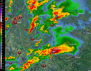
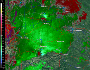
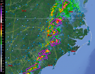
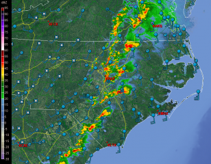
But I digress. Here are a few GR2AE radar grabs of the North Carolina supercells. Storm motions were to the northeast. The rest tells its own story if you know what you’re looking at.

First, here’s are a couple macroscopic views.

Next, I’ve zoomed in on the Raleigh radar to  cross-check reflectivity and storm-relative velocity on a couple supercells.

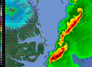
The final image was taken after the storms had moved out to sea. It shows a couple of northern line-end vortices that I found interesting and thought you might too.

____________________
* All numbers reflect preliminary reports at the time of this post’s publication. Final statistics will likely be different.
Chasing the Great Lakes Superbomb of 2010

Until early yesterday morning, I was pretty certain that I wasn’t going to be chasing yesterday’s squall line associated with the record-breaking low pressure system that’s moving across the Great Lakes. With storms ripping along at 60 knots, what kind of chasing is a person going to do?

Then came the 7:00 a.m. phone call from my chase partner, Bill Oosterbaan, informing me that the Storm Prediction Center had issued a high risk for the area just across the border in Indiana and Ohio. With the rapidly advancing cold front still west of Chicago, we’d have ample time to position ourselves more optimally. This would be an early-day storm chase. It would also almost surely be our last chase for the next four or five months. What did we have to lose?

I hooked up with Bill at the gas station at 100th St. and US-131, and off we went. The storms had moved into Chicago by then, and as we dropped south, it became apparent that we would also need to break east and then stairstep down into Ohio, buying time in order to let the line develop with daytime heating. Satellite showed some clearing in Ohio,

suggesting a better chance for instability to build. Catching I-94 in Kalamazoo, we headed east toward I-75, with the Findlay area as our target.

Off to the northwest in Minnesota, the low was deepening toward an unprecedented sub-955 millibar level, sucking in winds from hundreds of miles around like the vortex in an enormous bathtub drain. Transverse rolls of stratocumulus streamed overhead toward the north, indicating substantial wind shear. (Click on image to enlarge.)

By the time we crossed the border into Ohio, tornado reports were already coming in from the west as the squall line intensified. Soon much of the line was tornado warned. However, while the warnings were no doubt a godsend for a few communities that sustained tornado damage yesterday, they weren’t much help to Bill and me. Chasing a squall line is different from chasing discrete supercells.

We had in fact hoped that a few discrete cells would fire ahead of the line. But the forecast CAPE never materialized to make that happen, and we were left with just the line. In that widely forced environment, tornadoes were likely to occur as quick, rain-wrapped spinups rather than as the products of long-lived mesocyclones. Even with GR3, the likelihood of our intercepting a tornado would require a high degree of luck. It was harder to identify areas of circulation with certainty; I found myself using base velocity as much as storm relative velocity on the radar, and comparing suspect areas not with easy-to-see hook echoes in the reflectivity mode, but with kinks in the line. It was pretty much a game of meteorological “Pin the Tail on the Donkey.”

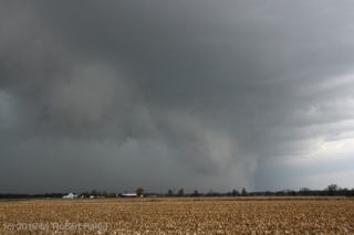
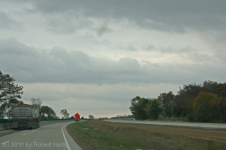
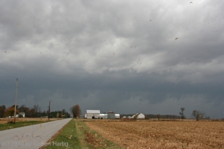
North of Kenton, we headed west and got our first view of the squall line. For all the hooplah that had preceded the thing, it didn’t appear very impressive. Just your average storm front–much windier than most, but also a bit anemic-looking compared to some of the shelf clouds I’ve seen. Still, it was a lovely sight, watching those glowering clouds grope their way across the late-October farmlands.

.

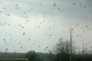
Neither of us was quite ready to end the chase, so with the storm rapidly closing in, we scrambled back into the car and stairstepped to the southeast in the hope of intercepting a likely-looking reflectivity knot that had gone tornado-warned. It was fun playing tag with the storm, driving through swirls of leaves spun up by the outflow. But there really wasn’t much incentive for us to continue the game indefinitely. Eventually we turned back west and drove into the mouth of the beast.

For a few minutes, we got socked with torrential rain and some impressive blasts of wind (and, I should add, absolutely no lightning or thunder whatever). Then it was over. Time to head home.

In Kenton, we grabbed dinner at a small restaurant. Then we headed toward Cridersville, 28 miles straight to the west next to I-75, where there had been a report of “major structural damage” from a tornado. The report was accurate. A small but effective tornado had torn through the community, uprooting and snapping off large trees, taking off roofs, and demolishing at least one garage that I could see. Of course we couldn’t get into the heart of the damage path, but a few passing glimpses suggested that some of the damage may have been fairly severe.

As I said at the beginning, this chase will likely have been my last of the year. I never know for sure until the snows fly, but it seems like a pretty safe bet that I won’t be heading out again after storms until March or April. It’s hard to call this chase a bust since our expectations weren’t all that high to begin with. Plus, tornadoes or no tornadoes, it was an opportunity to engage with a historical weather system. Like other significant weather events such as the Armistice Day Storm and the 1974 Super Outbreak, this one will be given a name in the annals of meteorology. Me, I’m calling it the Great Lakes Superbomb of 2010. In a number of ways, it hasn’t proved to be as impactful as was forecast, but it’s not over yet. And regardless, I’m glad I got the chance to get out and enjoy a final taste of synoptic mayhem.

The Tornado Fest That Wasn’t

Now that Sunday’s brouhaha in Tornado Alley is over and done, the big question seems to be, where were all the tornadoes? The turnout was there, the fans were waiting, but besides the rope and the wedge/multivortex/stovepipe that my buddies Bill and Tom witnessed near Crawford, Oklahoma, in company with a multitude of other chasers, there just wasn’t anything to make postcards out of. The big show never showed. Even the lone supercell that wandered north out of Texas into Oklahoma’s higher helicities never produced, despite its lack of competition. Oh, there were a couple of twisters in Kansas, and with a tally of four, Iowa had the most reports of all. Ironically,  it wasn’t even in the PDS high risk area.

This is by no means to criticize the crew at the SPC; those are some highly adept meteorological minds, the finest in the world. No, it’s just to muse at the vagaries of the weather. Rudimentary as my own forecasting skills are, I’ve nevertheless come to realize that no matter how good a forecaster one becomes, the weather is still the weather. Capricious. Subject to subtleties that no one gives weight to until after the fact. The butterfly beats its wings and a tornado fires up in Texas–or a seemingly volatile setup falls apart.

Judging from the YouTube videos and the photos posted on Stormtrack, a lot of people managed to be in the right place at the right time for the one storm in Oklahoma that did produce a couple very photogenic tornadoes. But the event was a far cry from high-risk mayhem.

Guess I can’t feel bad about that, since I was sitting at home nursing a chest cold while my mates were out there roaming the Plains. The cold now seems finally poised to start breaking up, and hopefully in another day or two I’ll feel halfway human again. It’s just as well that I get this nonsense out of the way now, so I’m up to snuff physically in a couple weeks when my buds and I head out to the Alley for an extended tour. I hope that by then, there won’t be any lack of the right ingredients in the atmospheric brew to make the trip worthwhile.