The Cap Won

I don’t know why so many storm chasers decided to chase in northern Missouri this last Monday. I could have told folks it had “cap bust” written all over it–didn’t fool me for a minute, as you can see by reading my post written the day before.

Ahem…right, so I got snookered too. The GFS was spot on about the cap, and the NAM way underforecast it. As a result, Missouri chasers wound up sitting under relentlessly empty skies waiting for convection to fire. It finally did in northeast Kansas–after dark. Storms ignited along a boundary (the warm front? ) and a couple went supercellular and even tornado-warned for a heartbeat before the cap re-exerted itself and squenched them.

The real action, ironically, took place in central Illinois and Indiana, well east of where most folks–including me–had expected. Supercells cut a swath along the warm front through Terre Haute, Indianopolis, and parts east and southeast into Kentucky, and a number of purple boxes lit up the radar screen. Nevertheless, SPC storm reports list only one confirmed tornado that touched down near Hillsboro, Illinois, northeast of Saint Louis.

Them’s the breaks. I didn’t chase that day, and I’m glad that I didn’t because I’d almost certainly have gotten skunked in Missouri when I could have driven straight south down US 41 to Terre Haute, not even having to mess with Chicago traffic, and waltzed on into the sweet zone.

Ah, well. I chased today–if chasing is what you can call a guaranteed grunge fest–down toward a warm front by the Michigan border. The trip was my compensation prize for not heading out when it really counted these past few days. The SPC had outlooked a five percent tornado risk this afternoon, and supercells were making their way northeast across Illinois toward Indiana. I figured that if they held together, I might catch them, but not surprisingly, they mushed out.

That was okay. I was chasing blind, with no radar and few expectations other than the hope that I’d at least see some lightning. I did, and called it good. The main storm season is still on the way, and there’s no need to fret over spilled milk when the cow is just priming its udder. It won’t be long now.
Tribute to a Storm Chasing Partner

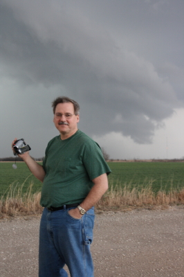
Wild Bill Oosterbaan, Chase Partner Extraordinaire

Wild Bill Oosterbaan, Chase Partner Extraordinaire

I contemplated cropping the above image to achieve a better visual balance. Then I thought, nah. For one thing, what’s the point of trying to balance the photo of a character who’s as wildly off kilter as Bill. For another, and all kidding aside, I’d have to trim out a good portion of the storm clouds. And that would be like trimming out the very essence of Bill Oosterbaan. You see, clouds like those are Bill’s passion. They’re what first brought us together thirteen years ago, and they’ve been propelling us across the miles ever since in search of convective mayhem.

Bill is my chase partner. Of course, I chase with some other great friends and storm chasers as well, but Bill…well, I’ve just covered more miles with him by far, paid more dues, experienced more busted chases, learned more about weather, and yes, seen more tornadoes and beautiful storms, than with anyone else. This post is my tribute to my fellow chaser, comrade in convection, and good friend of over a decade.

Bill and I are very different temperaments. Conduct a Meyers-Briggs personality profile of each of us and your first conclusion probably wouldn’t be that we ought to get in a car together and travel 1,000-plus miles at a stretch in search of intense, potentially lethal weather. But we’ve survived both the storms and each other, and learned quite a bit in the process. And, I might add, we’ve had a heckuva lot of fun.

I first met Bill back in 1996. That was the year I also conducted my first successful storm chase right here in Michigan. I had already done a chase or two with Bill and his brother, Tom, but on that sticky August day, the two of them were out on the golf course. So when a supercell fired up and formed a wall cloud right outside the window where I worked, I drove solo across the Kent and Ionia County countryside and scored a slim, elegant tube tornado north of Saint Johns.

On my chases since then, though, I’ve rarely been without Bill. So our development as storm chasers has followed a very similar track. I saw my first Great Plains tornado with Bill. In 2005 we chased the record-breaking Six State Supercell together from west of Columbia, Missouri, all the way back to Michigan. On two separate occasions, we’ve witnessed nighttime tornadoes strike large towns. Our technology has advanced from a miniature TV and stop-offs at airports  and libraries in order to access radar data, to laptops equipped with all the tools known and loved by storm chasers today. We’ve even figured out how to use most of the stuff. Our forecasting skills have grown from those early days of trying to decode the arcane language of SPC discussions, to making our own forecasts with increasing success.

Lately my laptop of four years has been giving me fits. This is  nothing new, but it has gotten to the point where I’ve finally ordered a new one from Dell. It’s a heavy-duty toughbook that’s made to take punishment, perfect for the road. Bill sees  in it the end of an era. He says he’s going to miss watching my eyes bulge and the veins pop out in my neck. I hate to deprive him of such a simple pleasure; it’s a small thing, and it causes him so much joy. On the other hand, I think he’ll agree that there’s a lot to be said for having a computer that doesn’t crash when we need it most. Typically that happens while we’re in pursuit of some rain-wrapped meso with who knows what lurking in its interior.

I look forward to tracking down plenty more mesos with my friend and long-time chase partner. Many more storms, countless more hours on the road, and yes, more arguments with the ornery cuss. Because the storms are what it’s about for both of us, and I think we’ve learned–and will continue to learn–plenty from each other about chasing them. Our respect for one another is mutual, as is our love for the wild, untamed beauty of Big Weather. When Bill and I talk, it’s mainly about storms. We never get bored. For us, talking about the weather is far from trivial conversation. There’s always something new to learn, something fresh to discover.

That’s why I refuse to trim those storm clouds out of the picture up above. To lessen their presence would be to lessen the story they tell about the man standing in front of them. They’re a vital part of Bill. So let the clouds remain and let the picture look a bit unbalanced. After all, Bill’s a storm chaser. What kind of balance do you expect out of a guy who hunts tornadoes?

Bill, mi amigo, it sure has been a blast. Here’s to you. Here’s to shared experiences, to the thousands of miles we’ve driven, and to the thousands we’ve yet to drive. Here’s to the the Lord who has kept us safe and blessed us with success.

And, as always, here’s to the storms.

Severe Weather Forecasting Workshop and Southern Plains Drought

It’s Thursday, and I’m in Louisville, Kentucky, with my buddy Bill. He’s got business here, and I’m taking care of business here on my laptop, and then we head to Norman, Oklahoma, for a severe weather forecasting workshop with Tim Vasquez. At times like this, I’m grateful for the freedom and mobility that come with being a freelance writer. As long as there’s work for me to do, I can do it pretty much anywhere provided I have my laptop and Internet access.

I’ve been hoping to catch a little early-season convective excitement this Saturday. Not sure that’s going to happen, though. The wild card seems to be moisture, but capping may also be a problem. It would be a shame to make the journey to Oklahoma and not see a little decent, Great Plains weather. Of course, that’s not the focus of the trip–the forecasting workshop is–but still, a supercell or two would be nice. Unfortunately, it looks like a cold front will provide the lift that finally busts the cap, and that suggests “linear.”

Sunday is the workshop, so I don’t much care what the weather does that day. I’ll be in class.

Monday may offer another crack at things, and it may be our best opportunity. It’s too far out to say (for that matter, Saturday is still a bit too far off yet to feel either good or bad about it), but assuming that the southern Plains at least get a bit of rain to relieve their dry spell and give the ground a good soaking, moisture may not be the question mark that it is for Saturday’s setup.

Frankly, the current forecast discussion on Stormtrack is the first time I’ve given serious thought to the effect of soil conditions on convection. I had always thought of ground moisture and evapotranspiration as just enhancements to the return flow, not potential deal-breakers. To my mind, a nice, deep low pulling in rich dewpoints from the Gulf of Mexico would more than compensate for dry regional conditions. But more than one seasoned Great Plains storm chaser has looked at the current drought conditions in Texas and Oklahoma and opined skeptically about the chances for 2009 being a good chase year in the West unless the region sees some rain.

Ah, well. The season hasn’t even begun yet, so I’ll take what I can get and hope for better as we move into May and June. Right now, it’s nice to simply see the sun shine, feel fifty-degree temperatures, and know that winter is drawing to a close.