An Independence Day Double-Header: Summer Weather Is Here

It’s July 4, Independence Day. Happy Birthday, America! For all the problems that face you, you’re still the best in so many, many ways. One of those ways, which may seem trite to anyone but a storm chaser, is your spring weather, which draws chasers like a powerful lodestone not only from the all over the country, but also from the four corners of the world.

no images were found

This has been an incredible spring stormwise, but its zenith appears to have finally passed for everywhere but the northern plains. And right now, even those don’t look particularly promising. That’s okay. I think that even the most hardcore chasers have gotten their fill this year and are pleased to set aside their laptops and break out their barbecue grills.

Now is the time for Great Lakes chasers to set their sights on the kind of weather our region specializes in, which is to say, pop-up thunderstorms and

no images were found

squall lines. The former are pretty and entertaining. The latter can be particularly dramatic when viewed from the eastern shore of Lake Michigan, sweeping in across the water like immense, dark frowns on the edge of a cold front. If you enjoy lightning photography, the lakeshore is a splendid place to get dramatic and unobstructed shots. Not that I can speak with great authority, since so far my own lightning pictures haven’t been all that spectacular. But that’s the fault of the photographer, not the storms.

The images on this page are from previous years. So far this year I’ve been occupied mainly with supercells and tornadoes, but I’m ready to make the shift to more garden variety storms, which may not pack the same adrenaline punch but lack for nothing in beauty and drama.

July 4th is a date that cold fronts seem to write into their planners. I’ve seen a good number of fireworks displays in West Michigan get trounced by a glowering arcus cloud moving in over the festivities. But tonight looks promising for Independence Day events. Storms are on the way, but they should hold off till well after the party’s over.  That means we’ll get two shows–the traditional pyrotechnics with all the boom, pop, and glittering, multicolored flowers filling the sky; and later, an electrical extravaganza, courtesy of a weak cold front. A Fourth of July double-header: what could be finer than that?
A Glance at Friday: Severe Weather in the Great Lakes

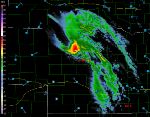
It now seems a sure bet that the eastern Great Lakes is due for a spate of severe weather. The SPC is presently making it out to be a linear event, as is typical of cold fronts sweeping through our region, but the wind profiles suggest the possibility of supercells and tornadoes.

If you go by the present, 12Z NAM run, central Ohio appears to be the sweet spot, with a variety of parameters converging over or near a bullseye of 2,000 j/kg SBCAPE. Here are a few maps for forecast hour 21Z to give you an idea. Click on the images to enlarge them. The first shows the aforementioned SBCAPE (shaded), sea level pressure (contours), and surface wind barbs. Not a bad bit of instability if this scenario pans out.

In the second image, you can see a nice overlay of 55-60 kt 500 mb winds (shaded) over 35-40 kt 850 mb winds (contours). The wind barbs are for the 850 mb level. The H5 winds veer still further to the west. I think it’s safe to say that shear won’t be an issue, and 1 km VGP, not shown, is as high as 0.4 in the area of heightened instability. Helicity maxes are well to the north, but I wonder what kind of effective SRH we’ll wind up with where it counts.

The third map shows a Theta-e lobe pushing up into northern Ohio with a surface lifted index between -4 and -6 perched squarely over the axis. That should get the job done.

In the last map, three different significant tornado parameters–the well-known STP, the APRWX tornado index, and the Stensrud tornado risk–all converge nicely over the same spot near Newark, Ohio. Three overlays can be a bit difficult to decipher, so let me help: the STP is shaded, the APRWX is tightly contoured like an onion, and the Stensrud has broader

contours, with its highest value circling the APRWX in a yellow ring.

All this to say, Friday may have some potential. I don’t get too excited about cold front events around here–not that we have many options in the Great Lakes, but a steady diet of squall lines has a way of lowering a person’s expectations. Of course, as soon as you let down your guard, along comes the exception to prove that storms in our area can and do deliver. Maybe this round will prove to one of those occasions. We’ll find out two days hence.