That’s right, fellow storm chasers, you read my headline right. I’m about to raise a few eyebrows by tossing out the possibility that backing winds–or, more precisely, what we normally consider to be backing winds as depicted on forecast maps–aren’t always vital to tornadic storms.* This isn’t speculation as much as it is observation. Over the years I’ve seen a number of tornadic events develop in the midst of southwest surface flow, enough to think that the absence of southeasterly winds on the forecast map isn’t always a deal breaker.
What is indispensable are the conditions that southeasterly boundary layer winds tend to create. I’m thinking of ample deep-layer moisture and sufficient low-level storm-relative helicity. Those are what count. If they are present, it doesn’t much matter which way the wind blows from our perspective. The atmosphere sees things differently and doesn’t care what we think. It just does what it does.
Let me quickly say, I’m a huge fan of southeasterly surface winds. I love to see them on forecast maps. And I’m aware that winds can back locally in ways that the maps don’t portray. What I’m really talking about here is forecasting using the tools we have to work with, which continue to improve. Until last year, for instance, I’d never heard of the HRRR. It’s a marvel. But generally speaking, in contemplating the prospects for a chase day we’re still dealing with pretty broad brush strokes, and the farther we live from Tornado Alley, the better we need to be at determining how those strokes will play out.
A Regional Thing?
In writing about forecasting matters, I still feel very much like a neophyte who may be getting into matters that are over my head. I’m no Jon Davies or Chuck Doswell. I’m not even a meteorology student. But you know the old saying about fools, angels, and where they tread.
My sense of things is that as we move east of the Mississippi, southeasterly surface winds become less important for moisture fetch–and, I might add, southwesterly 850s aren’t such a terrible thing. Why? For one thing, moisture sources in the Gulf of Mexico no longer lie to the southeast, but to the south, and even to the southwest in eastern parts of the CONUS. Also important, the desert southwest isn’t nearly so proximate an influence. Thus, H85 winds that would kill a setup with dry air advection in Oklahoma can carry moisture up into Illinois and Indiana. Moreover, that moisture is apt to follow a curvy path–one that can, for instance, take it first northwest from the Gulf, then north, then northeast up into the Great Lakes.
All that to say that the trajectory of moisture transport can look different in different parts of the country.
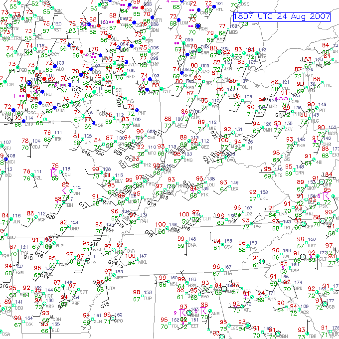
As for helicity, does it really matter whether you’ve got southeasterly, or even southerly, surface winds as long as 0-1km SRH is in the neighborhood of 150 or greater? Years of reading convective outlooks leads me to believe that the SPC doesn’t think so. What I’m saying here is no doubt old hat to them. But it may seem a bit out of the box to at least some storm chasers, particularly those whose thinking has been conditioned by setups in the southern and central Great Plains. The whole concept of storm-relative helicity suggests that the term backing is, well, relative, a matter of how winds relate to a storm as it moves, not to the compass. That’s why right-turners produce. A few days ago in Pennsylvania, overall storm motion was consistent with unidirectional winds from the west; yet a rogue supercell deviated to the right and spun up a tornado near Greensburg.
A Few Examples
Seeing is believing. Here are a few maps that show surface conditions around the time of tornado incidents east of the Mississippi.
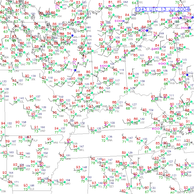 The July 12, 2004, Roanoke, Illinois, tornado is an example of a classic northwest flow event. Rated F4, the tornado was large, long-lived, and not the first violent tornado to occur in northwest flow during the warm season in Illinois. Four years earlier, the disastrous 1990 Plainfield F5 was fueled by massive CAPE amid northwest flow.
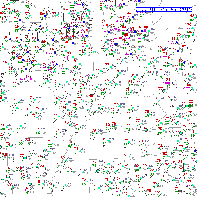
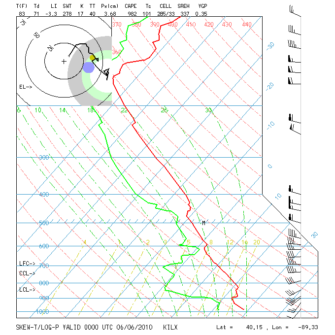 The June 5, 2010, central Illinois outbreak was a sort of quasi northwest flow situation. Mid-level winds were predominantly westerly with just a slight northerly component to them. The surface and 850 winds were unquestionably veered. Besides the surface map, I’ve also included the ILX 00z sounding, which preceded tornadogenesis by roughly an hour.
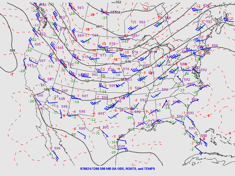 Finally, the Potterville, Michigan, tornado practically dropped in my lap, but I ignored what the radar was showing me because I was too dumb to believe my eyes even when the dynamics were plainly visible in the clouds right over my head. This was not a northwest flow event; in fact, as you can see by comparing the surface and 500mb maps, it looked to be unidirectional from the southwest, with directional shear increasing as the trough moved east and mid-level winds became more westerly.
You can find plenty more examples besides these, I’m sure. My point is simply this: Don’t be too quick to write off a synoptic setup because of veered surface winds in the forecast, particularly east of the Mississippi. If moisture is in place and there’s reason to hope for adequate SRH, then it can pay to take a deeper look. Things could pop. They’ve done so before and they’ll do so again.
_______________
* ADDENDUM, March 3, 2013: The term “backing” has a couple of different applications. I used it a bit naively in the title and copy to mean southeasterly surface winds, which is the meaning by which I first came to understand the word. That becomes apparent quickly in the article, but it bears explaining. If I were writing this post today, I’d simply say “southeasterly” and erase any uncertainty of what I meant.


